Lots of swell with offshore winds
Southern Tasmania Surf Forecast by Craig Brokensha (issued Wednesday 14th May)
Best Days:
Recap
A lift in new SW swell yesterday, coming in around 2ft, while this morning a bit more size than expected was seen with solid clean 3ft waves out of the S/SW on the coast.
This week and weekend (Jun 15 – 18)
Today's S/SW swell will ease back overnight, only to be replaced by a strong but inconsistent W/SW groundswell tomorrow.
This swell should keep 3ft sets hitting Clifton tomorrow, most consistent into the afternoon with a reinforcing mid-period W/SW swell, easing back from 2-3ft Friday morning.
Also in the mix should be some S/SE groundswell from a polar fetch of gale to storm-force SE winds in our swell window Sunday and Monday.
This swell is likely to come in at 2ft+ but will be hard to distinguish under the W/SW swells.
Conditions look great tomorrow with a N/NW tending variable breeze, similar Friday.
The surf should continue to ease back from 1-2ft Saturday morning, but into Sunday we're due to see three separate swells fills in.
 The first and smallest will be a W/SW groundswell from a broad and good pre-frontal fetch of W/NW gales moving in from under WA, under the Bight tomorrow.
This will be however followed by post-frontal severe-gale W/SW winds, producing a better aligned SW groundswell for Sunday morning.
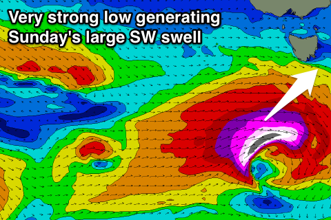
Then the third and largest swell looks to be generated by a very intense low developing west-southwest of us Friday evening, with a fetch of storm-force W/SW winds projected quickly through our western and then south-western swell window.
What we should see is all three swells filling in concurrently, likely causing weird and funky double-ups, but a solid spike in size to the 4-5ft range is due during the day across Clifton with all day offshore NW winds.
We should see the swell then easing into early next week as offshores continue.

