A couple of fun swell pulses, wrecked by winds
Southern Tasmania Surf Forecast by Craig Brokensha (issued Monday 5th June)
Best Days: Wednesday morning, Saturday morning
Recap
Tiny clean waves over the weekend, best suited to beginners with the swell being too west to get into Clifton.
Today a stronger but inconsistent W/SW groundswell has provided better 2ft sets with light offshore winds. This was generated by a very strong frontal progression through the Indian Ocean, hence its inconsistency.
This week and weekend (Jun 6 – 11)
Today's increase in W/SW groundswell should continue through tomorrow, mixed in with some mid-period energy generated by a mid-latitude front currently approaching from the west.
This should keep 2ft waves hitting Clifton, but winds will be terrible in the wake of an overnight change, leaving strong S/SW breezes across the coast.
Wednesday looks nice and clean, but the swell only small and easing from 1-2ft.
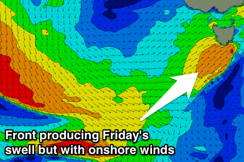
Tiny waves are due into Thursday, but come Friday, a good new W/SW groundswell is due, mixed in with short-range energy.
The groundswell is being generated by another distant but strong storm in our far western swell window. The storm generating this swell will track just a little too north and out of our swell window, but once it weakens and crosses us Thursday, a secondary small mid-latitude front is due to push across us into the evening and early Friday.
 This will produce a short-range mid-period W/SW swell also for Friday, supplementing the long-range energy and coming in at 2ft itself.
Winds will again be poor though in the wake of the front with strong SW winds Friday.
Easing surf with an early W/NW offshore is then on the cards Saturday, tiny Sunday morning.
Longer term we may see a small spike in W/SW groundswell Sunday afternoon and Monday morning but there are hopefully some better developments through mid-late next week. More on this Wednesday.
Conditions look good all of Friday with a W/NW breeze, while Saturday will see N/NW winds all day.
Behind this swell another similar low will generate another long-period WSW groundswell, but this system will be a touch too far north, with the swell being too west to get in Sunday afternoon. Only 1ft+ waves are expected.
Longer term there's nothing major due, so try and plan around the small swells due over this period.

