Good swell but with dicey winds
Southern Tasmania Surf Forecast by Craig Brokensha (issued Friday 21st April)
Best Days: Sunday late morning onwards, Monday morning, Tuesday, Thursday
Recap
Wednesday's strong swell eased back from a clean 2ft yesterday morning, back to a tiny 1ft this morning.
A slight kick in new W/SW swell is due later today, possibly to 1-2ft but conditions are now bumpy with weak sea breezes.
This weekend and next week (Apr 22 - 28)
Any increase in size this afternoon will back off into tomorrow morning, back from 1-1.5ft with a morning offshore.
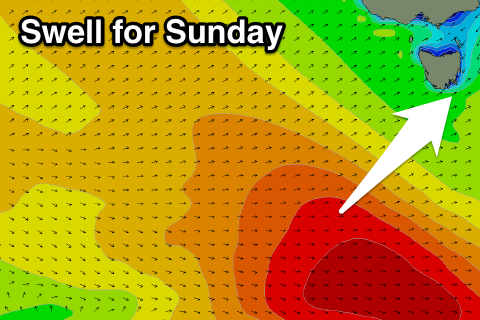
Of greater importance is Sunday's swell, with a strong mid-latitude front currently dipping east-southeast towards the polar shelf while generating a good fetch of gale to severe-gale W/NW winds.
 This will then be followed by weaker post-frontal W/SW gales, producing two seperate swells. The first from the W/SW for early Sunday and the second more SW swell for the afternoon.
Clifton should see 1-2ft sets Sunday morning, kicking to 2ft+ through the afternoon, easing back from 2ft Monday.
Winds on Sunday are now looking dicey as a weak surface trough moves across us, bringing light to moderate S/SE breezes, tending more variable through the day. It won't be great but there should be some OK waves for keen surfers. Monday will then be clean again as the swell eases.
Into next week small to moderate pulses of SW swell are due from a broad but relatively weak and unconsolidated polar frontal progression moving in from the west.
The first increase Tuesday should see Clifton building to 2ft, while a trailing front pushing up and into us Wednesday will kick up a mid-period increase in SW swell to 3ft+ or so.
Offshore winds are on the cards for Tuesday, but Wednesday looks poor with a gusty SW'ly associated with the front. Thursday is the pick as the SW swell eases from 2-3ft with NW winds most of the day.
Longer term there's a bit more swell on the way, but more on this Monday. Have a great weekend!

