Fun weekend, large powerful swell for Wednesday
Southern Tasmania Surf Forecast by Craig Brokensha (issued Friday 14th April)
Best Days:
Recap
Wednesday's swell eased back to 2ft yesterday and conditions were great again for most of the day.
Today tiny waves were seen to 1-1.5ft, but a new W/SW is due to show later today to 1-2ft and Cape Sorell has risen accordingly.
This weekend and next week (Apr 15 - 21)
This afternoon's increase in W/SW swell will be followed by a slightly better increase tomorrow, generated by a zonal but strong front moving in from the west and crossing us today.
1-2ft waves are due most of tomorrow with favourable offshore NW winds.
Sunday's better and stronger W/SW groundswell is on track with satellite confirmation of a severe-gale to storm-force W/SW fetch in our far swell window. This low has since weakened and is approaching to our south-west.
The swell isn't due to be in at dawn, with 1-2ft waves, but a solid kick into the afternoon to 2-3ft is expected, easing back from 2ft Monday.
A morning N/NW breeze is expected to swing W/NW early afternoon and maybe W/SW later, but there should be a window of clean conditions and decent swell Sunday.
 Monday looks clean most of the day ahead of mid-late afternoon sea breezes.
Tuesday morning should be tiny, but later in the day some new W/SW groundswell should develop across Clifton.
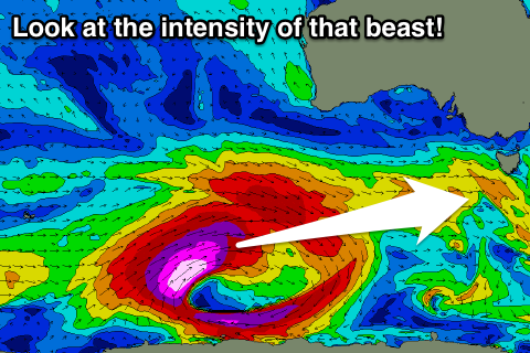
This will be generated at the head of a vigorous polar frontal progression firing up through the Southern Ocean this weekend.
A pre-frontal fetch of severe-gale W/NW winds will produce this W/SW groundswell, kicking late in the day to 2ft across Clifton, while behind it a significant fetch of storm-force W/SW winds will generate a large, powerful, long-period and better aligned W/SW groundswell for Wednesday.
The swell is due to arrive overnight, peaking Wednesday morning to 3-5ft across Clifton, easing through the day and back from 2ft to possibly 3ft Thursday morning.
Winds on Wednesday are excellent with offshore N/NW tending N/NE breezes, and likely E/NE later, with offshores again Thursday.
Beyond this the storm track looks a little too far north for us, but more on this Monday. Have a great weekend!

