Small to tiny W/SW swell ahead of a S/SE pulse Sunday
Southern Tasmania Surf Forecast by Craig Brokensha (issued Wednesday 1st February)
Best Days: Friday at magnets, similar Saturday morning, Sunday morning
Recap
A good increase in W/SW groundswell to 2ft yesterday, with a mid-period W/SW swell into the afternoon, with both easing back from 1-1.5ft this morning.
This week and weekend (Feb 2 - 5)
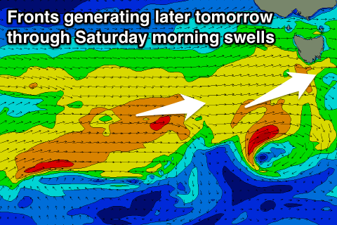
Tomorrow morning is still expected to be a low point in activity with tiny clean 1ft waves, but into the afternoon some new W/SW swell is due from a weak front moving in and across us.
This should build to 1-1.5ft by dark, but the strength of the system has been downgraded a little, so Friday's peak only looks to be a similar 1-1.5ft.
 A secondary front moving through should keep 1-1.5ft waves persisting until early Saturday before fading through the day.
Winds tomorrow look to hold from the W/NW for most of the day with NW breezes Friday and Saturday morning, giving into SE sea breezes on the later.
There's nothing major due into Sunday or early next week with tiny background W/SW swell to 1ft, mixed in with some inconsistent S/SE groundswell.
The fetch along the polar shelf is within our swell window and not on the ice-shelf and while small, winds are forecast to reach the severe-gale to storm-force range.
We should see this generate a small inconsistent S/SE groundswell for the weekend, building Saturday afternoon and reaching 1-2ft, peaking Sunday to 2ft and then easing Monday.
Winds on Sunday look great and offshore from the N/NW ahead of a late change.
Longer term there's nothing significant on the cards, but more on this Friday.

