Onshore building swell tomorrow, easing and cleaning up later Sunday
Southern Tasmania Surf Forecast by Craig Brokensha (issued Friday 4th November)
Best Days: Later Sunday, Tuesday, Wednesday morning
Recap
Tiny fading 1-1.5ft waves yesterday, with even smaller surf today.
This weekend and next week (Nov 5 - 11)
Our tricky forecast for the weekend is still that, but all in all it's an upwards trend with onshore winds tomorrow, easing through Sunday with no reinforcing swell for the afternoon due any more.
Currently a vigorous front is approaching from the west, but the fetch is just that, very west.
As the system moves under us this evening and early tomorrow, a fetch of upper W/SW gales will be generated in our south-western swell window, persisting most of tomorrow. This should see Clifton building to an easy 3ft if not more through the day but with strong W/SW winds.
With the low moving off to the east Saturday evening, a steady drop in size will be seen Sunday from 2-3ft.
Now, conditions are looking average Sunday with a fresh W/SW breeze due to continue through the morning, but a swing back to W/NW breeze is due later in the day when the swell is smaller.
 Our small secondary pulse of S'ly swell due Monday/Tuesday from a more polar fetch of S/SW winds in our swell window is still on track, but this will be hard to distinguish under a better W/SW swell.
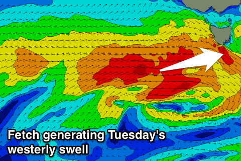
This swell will be produced by a strong mid-latitude front strengthening as it passes under the Bight and moves towards us Sunday and Monday.
A good fetch of W/SW gales should produce a good W/SW groundswell to 2-3ft through Tuesday afternoon when it peaks, under NW winds. The swell will be very west in nature and not favourable for protected spots.
A slow drop in size is then due from Wednesday with an early W/NW offshore.
Longer term there's nothing significant, so try and work the coming windows of swell. Have a great weekend!

