A couple of swells to come but with average winds
Southern Tasmania Surf Forecast by Craig Brokensha (issued Friday 21st October)
Best Days: Limited windows, Tuesday morning
Recap
Wednesday's swell backed off from a small clean 1-2ft yesterday morning, tiny into this morning.
This weekend and next week (Oct 22 - 28)
Unfortunately the weekend isn't looking good at all any more, with a deepening low off our East Coast due to influence our local winds.
A S/SE breeze tomorrow will spoil a new swell to 1-2ft, with a junky S/SE windswell and S/SW winds on Sunday but again not above 2ft.
Monday morning should reveal cleaner conditions as the low moves off to the east, but tiny waves are due for most of the day.
Into the mid-late afternoon our new SW groundswell from a pre-frontal fetch of W/NW gales is expected.
 Clifton should kick to 2ft+ later in the day, easing from 2ft Tuesday morning. An early W/NW'ly is likely Monday morning, onshore from the W/SW into the afternoon, while Tuesday is expected to see N/NW tending N/NE winds.
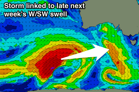
The stronger W/SW groundswell due late week is still on the cards, but winds may be an issue again.
This swell will be inconsistent but good, with a vigorous polar low forming in the Heard Island over the weekend, projecting towards the Bight while generating a fetch of severe-gale to storm-force W/SW winds.
The swell should kick later Thursday to 2-3ft across Clifton, but with an onshore SW change, easing from a similar size Friday morning with a possible lingering S'ly. We'll have to review this Monday. Have a great weekend!

