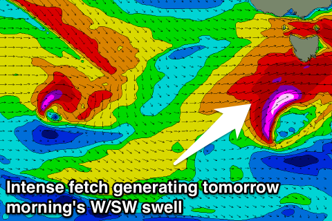
Strong but rapidly easing swell tomorrow
Southern Tasmania Surf Forecast by Craig Brokensha (issued Wednesday 5th October)
Best Days: Thursday, dawn Saturday keen surfers, early Sunday
Recap
Tiny waves again yesterday, while today a new W/SW swell has offered a touch more size to 1-1.5ft, but for the most part it's tiny.
This week and weekend (Oct 6 - 9)
 Tomorrow morning's strong increase in close-range W/SW swell is still on the cards, with a vigorous mid-latitude low currently taking shape to our south-west, with it due to produce a fetch of severe-gale to storm-force W/SW winds quickly through our swell window.
The size expected across Clifton has been upgraded a little, with 3-4ft sets due tomorrow morning, easing rapidly through the day back to 2ft into the afternoon, tiny Friday morning.
Conditions should be clean with a W/NW tending N/NW breeze during the morning, back to the W/NW into the afternoon.
Friday morning we'll fall between swells, but a weakening and stalling mid-latitude front moving slowly under us should produce a new W/SW swell for later in the day, peaking Saturday to 2ft+.
Winds are unfortunately looking average Saturday with a dawn W'ly giving into a W/SW tending SW change as the front moves off further to the east.
Sunday will be cleaner but fading from 1-2ft.
Into next week we're due to see an intense mid-latitude low forming south-west of the country and this will generate a fetch of severe-gale to storm-force W/SW winds that look to be just on the edge of our swell window at this early stage.
If this plays out as forecast we can expect some moderate sized W/SW groundswell later Monday and Tuesday, but more on this Friday.

