Large powerful swells this week
Southern Tasmania Surf Forecast by Craig Brokensha (issued Monday 25th July)
Best Days: Tuesday, Wednesday afternoon, Thursday, Friday, Saturday
Recap
Small waves to 2ft Saturday morning ahead of a strong kick in swell through the afternoon but with W/SW winds.
Sunday however was maxing with a mix of large S/SW and building S/SE groundswell coming in around 4-6ft with offshore winds. There should of still be 3-4ft of S/SE groundswell in the mix today, but reports were smaller and to 2-3ft.
This week and weekend (Jul 26 - 31)
Our run of solid swell will continue over the coming days.
Tomorrow afternoon and Wednesday we've got a large W/SW groundswell on the cards, generated by a vigorous mid-latitude front pushing across us from this evening.
As the front moves across us it will stall slightly through tomorrow, aiming a fetch of severe-gale to storm-force W/SW winds directly under us.
This will produce a large building W/SW groundswell through tomorrow, small in the morning and likely 2-3ft, building to an easy 4-5ft by dark, easing back from 3-5ft Wednesday morning.
 Winds are looking great tomorrow as the low dips south with strong W/NW tending lighter NW winds due into the afternoon, while Wednesday will be poor early with an onshore SW'ly, tending W/NW into the afternoon.
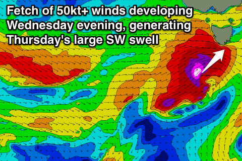
Now heading into Thursday an even stronger mid-latitude front is expected to intensify under us. This will generate a fetch of storm-force SW winds right through our southern swell window Wednesday evening and early Thursday, kicking up a large SW groundswell.
Easy 6ft sets are due across Clifton through the morning, easing noticeably later in the day, further Friday but slowed by some reinforcing W/SW swell from another weak front passing under us.
Winds Thursday are a little dicey but should hold from the W through the morning, tending more W/NW into the afternoon with offshores Friday and Saturday.
Longer term we've got some W/SW swell on the cards for next week, but we've got bigger fish to fry.

