Mix of swells over the weekend, best Sunday and filling in from the S/SE
Southern Tasmania Surf Forecast by Craig Brokensha (issued Friday 22nd July)
Best Days: Sunday, Monday, Tuesday morning, Wednesday morning, Thursday morning
Recap
A strong kick in W/SW groundswell Wednesday afternoon eased back from 2-3ft yesterday morning, with this morning being smaller and back to 1-2ft.
This weekend and next week (Jul 23 - 29)
A strong change that's due to whip through this afternoon isn't due to generate any meaningful swell for tomorrow, but a secondary stronger burst of W/SW gales moving in around dawn tomorrow, should kick up some new swell through the day, with a better aligned fetch of S/SW gales developing from 4pm or so.
With this we can expect a slow and tiny start to the day tomorrow, increasing from the W/SW to 3ft+ through the mid-late afternoon, possibly a bit bigger later, but winds will be onshore from mid-morning.
Into Sunday a good S/SW swell is expected from the S/SW fetch, and this will ease through the day, only to be replaced by a S/SE groundswell into the afternoon from a fetch of gale to severe-gale S/SE winds aimed through our swell window this evening and tomorrow.
Clifton should see 3-4ft waves Sunday morning, with the S/SE groundswell kicking to a stronger 3-5ft through the day.
This will be under favourable NW-N/NW winds, so keep an open mind re searching for waves.
The S/SE groundswell is due to ease through Monday from 3-4ft as winds continuing from the N/NW to NW.
As talked about last update, a strong and drawn out node of the Long Wave Trough is forecast to move across our swell windows next week.
This will direct a series of vigorous polar fronts through our western swell window next week.
The first will develop around Heard Island this afternoon, generating severe-gale to storm-force W/SW winds, projecting east-northeast towards us into the weekend and pushing across us Monday.
 What will result is a building short-range W/SW swell from the frontal system pushing across us Tuesday, increasing from 3ft through the morning to a larger 4-5ft by dark, with the groundswell peaking Wednesday morning to 3-4ft+, mixed in with the easing short-range energy.
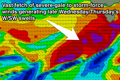
Another fetch of severe-gale to storm-force W/SW winds forming to our south-west and under us Wednesday is expected to produce a secondary pulse of W/SW groundswell later Wednesday back to the 5ft+ range, easing back slowly Thursday from 4-5ft or so, slowed by yet another reinforcing swell into the afternoon.
Winds look to generally be from the W/NW to W/SW favouring protected spots, but this and the swells are due to change, so check back for another update Monday. Have a great weekend!

