Solid windy swell developing Wednesday, easing into the end of the week
Southern Tasmania Surf Forecast by Craig Brokensha (issued Monday 11th July)
Best Days: Protected spots keen surfers Wednesday, Thursday, Friday
Recap
Small clean fading surf from 1-2ft Saturday while Sunday was tiny with no real surfing options. This morning the surf remained tiny and will so until Wednesday.
This week (Jul 12 - 15)
There's a lot of activity occurring up in the Bight and across South Australia at the moment and it's all too north and west in nature to influence us.
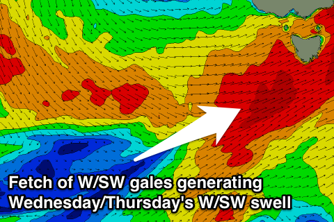
 Come Wednesday we'll see the slow moving and very cold outbreak moving east and across us. With this a fetch of gale to severe-gale W/SW winds will be projected into the state, bringing low level snow and a building W/SW swell through the day which is expected to only get sizey into the afternoon.
In the morning smaller 2ft to maybe 3ft waves are due, kicking through the afternoon to a large 4-5ft+ by dark. The frontal activity will continue with strength across and below us Wednesday evening and Thursday while tending more westerly in nature.
This will keep solid levels of W/SW groundswell impacting Clifton around 3-5ft Thursday, easing off from 3ft to maybe 4ft Friday morning.
Conditions Wednesday early will be OK with a W'ly wind, swinging strong W/SW through the mid-morning while Thursday looks great most of the day in protected spots with fresh to strong W/NW winds. Friday should then see improving W/NW tending NW winds.
Into the weekend small to tiny amounts of refracted W/SW groundswell are possible across Clifton from less than favourably aligned fetches of W/NW gales. 1ft to maybe 2ft sets are possible Saturday afternoon, tiny Sunday and under offshore winds.
Longer term there's nothing too significant so make the most of the coming waves.

