Lots of swell to come, largest Sunday morning
Southern Tasmania Surf Forecast by Craig Brokensha (issued Wednesday 23rd March)
Best Days: Every day over the coming period
Recap
A strong and powerful SW groundswell filled in yesterday morning with 3-4ft sets across Clifton under offshore tending variable winds. Other locations were better with less closeouts.
The swell dipped away overnight leaving tiny leftovers this morning.
This week and weekend (Mar 24 - 27)
From tomorrow a series of strong swells are due across the coast, the biggest due through Saturday afternoon and Sunday morning.
Currently a strong frontal system is moving in from the west, generating a fetch of SW gales right on our doorstep.
A good SW groundswell pulse should be generated by this low, peaking through the morning tomorrow to a good 2-3ft across Clifton, before easing into the afternoon, back to the 2ft range on the sets Friday.
Conditions should be clean all day tomorrow with a NW tending variable wind, and then all day offshores Friday.
Into later Friday and more so Saturday morning, a good new W/SW groundswell is due from a pre-frontal fetch of W/NW gales through our western swell window. This should provide 2ft+ waves across Clifton, but a better aligned post-frontal SW fetch is expected to generate a stronger afternoon increase in SW swell to 3ft+ across Clifton.
Conditions will be choppy though with a fresh NW offshore due to give into an afternoon W/SW change.
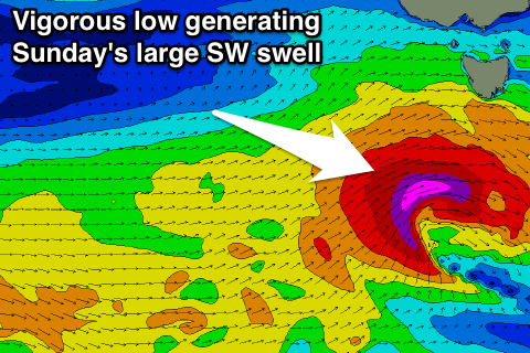
The strongest of all the storms will move in through Friday and Saturday, producing a fetch of severe-gale to storm-force W/SW winds through our south-western swell window.
 The swell from this low may be seen on dark Saturday but a peak is due Sunday morning to a strong 4-5ft across Clifton, easing into the afternoon but slowed Monday but a weaker reinforcing front pushing up into us.
This front should steer winds NW for a period Sunday morning before pushing further east across us bringing a W/SW change.
Monday looks clean again with easing 3ft surf.
Longer term a very strong polar low forming south of WA and pushing slowly east is expected to produce some strong W/SW groundswell for later in the week, but more on this Friday.

