Good swell pulses this week with workable winds
Southern Tasmania Surf Forecast by Craig Brokensha (issued Monday 7th March)
Best Days: Tuesday, Wednesday morning, Thursday from mid-morning, Friday morning, Sunday, Monday
Recap
Tiny clean waves Saturday morning, with a very slight lift in swell Sunday morning to 1-1.5ft, ahead of a stronger increase in SW groundswell through the afternoon to the 2ft range but with onshore winds.
The swell peaked this morning to a strong 2-3ft with variable winds ahead of gusty S/SE sea breezes.
This week (Mar 8 - 11)
A drop in size should have been seen this afternoon ahead of a stronger new SW groundswell tomorrow. This swell has been and is still being generated by a slow moving and strong polar front pushing along the polar shelf.
With this we should see Clifton build to a strong 3ft through the day, with the odd bigger bomb possible, easing back from 2-3ft Wednesday morning.
Conditions are looking clean tomorrow morning with a variable breeze again but a sea breeze will battle freshening NE winds, making for less than ideal conditions either way.
Wednesday will be clean through the morning with a fresh N/NW'ly ahead of a gusty W/SW change through the afternoon.
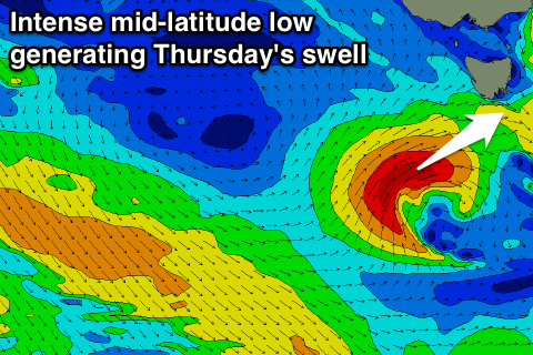
This change will be linked to a tight and intense mid-latitude moving in from the west, with it aiming a fetch of gale to severe-gale W/SW winds right into us.
 This should produce a fresh pulse of close-range SW swell for Thursday morning in the 3ft range, easing back into the afternoon and back to a small 1-2ft Friday.
Due to the close-range nature of the swell producing front, winds will vary through the day, with a dawn onshore S/SW breeze due to ease back through the morning and tend variable and then E'ly into the afternoon, back offshore Friday morning.
This weekend onwards (Mar 12 onwards)
Fading surf with morning W/NW winds is due on Saturday, while into Sunday a new long-range and inconsistent W/SW groundswell is expected, with small further pulses due most of next week.
The long-range swell has already started to be generated in our far far swell window south-west of Heard Island by a deep polar low.
This low will traverse along the polar shelf generating W'ly gales before weakening while projecting north-east towards the Bight later this week. Clifton should see very inconsistent 2ft sets, with a stronger more consistent pulse likely Monday from an unfavourably tracking polar low, but more on this Wednesday.

