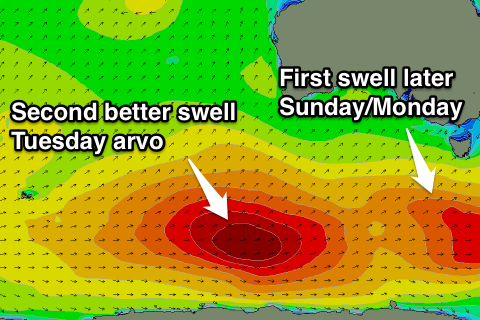
New swell late Sunday, peaking Monday, better pulse Tuesday
Southern Tasmania Surf Forecast by Craig Brokensha (issued Friday 4th March)
Best Days: Early Monday, Tuesday
Recap
Tiny waves yesterday morning, while a late increase in new W/SW groundswell was seen, peaking this morning with offshore winds and fun 1-2ft sets. This swell should fade into this afternoon as sea breezes develop.
This weekend and next week (Mar 5 - 11)
Tomorrow will be clean through the morning but only tiny 1ft surf if that is expected across Clifton.
From later Sunday through early to mid-next week we've got some good SW groundswell pulses on the cards from a flurry of strong polar frontal activity.
The first swell for later Sunday and Monday morning will be generated by a strengthening polar front right to our south-west tomorrow, with a fetch of gale to severe-gale W/SW winds firing up south-west of us.
 A late kick to 2ft is due Sunday, holding a similar size Monday morning before easing.
Tuesday will see the new pulse of SW groundswell moving in, from a slower moving fetch of W'ly gales on the same track as the system before.
This swell should build to a peak through the afternoon to a strong 3ft, easing from 2-3ft Wednesday morning.
Conditions are looking a little dicey with an early W/NW breeze Monday due to give into a S/SW change, with more variable winds, likely from the N/NW due Tuesday morning ahead of afternoon sea breezes. Wednesday then looks poor as a gusty S/SW change moves through.
Longer term we've got easing levels of swell on the cards, but more on this Monday. Have a great weekend!

