Fun swell tomorrow and Wednesday, stronger swell Sunday
Southern Tasmania Surf Forecast by Craig Brokensha (issued Monday 8th February)
Best Days: Tuesday morning, Wednesday morning, Saturday morning, Sunday, Monday morning
Recap
Good clean waves with plenty of swell to 2-3ft Saturday morning, easing back from a tiny 1-1.5ft.
Today the surf bottomed out with tiny 0.5-1ft sets ideal for beginners.
This week and weekend (Feb 9 - 14)
Tomorrow's pulse of W/SW groundswell has been moving around a bit since last week, and after a downgrade on Friday, we're now looking at an upgrade.
The frontal system generating this swell is currently under us, generating a patchy fetch of strong to gale-force W/SW winds.
This should produce a fun W/SW groundswell to the 2ft range tomorrow, holding early Wednesday morning before easing into the afternoon.
Conditions should be clean with N/NW offshores tomorrow morning ahead of afternoon sea breezes, with Wednesday morning playing out similarly.
Tiny surf is due through Thursday but a new inconsistent W/SW groundswell is due to build Friday afternoon and ease through Saturday. This swell will be more west than tomorrow's and from a weak frontal progression mainly 1ft surf due, with the odd 2ft bomb. Conditions are looking nice each morning again with offshores ahead of sea breezes.
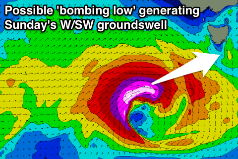
 Into the weekend, a weak frontal system moving in from the west is expected to 'bomb' and drop over 24hPa in less than 24 hours during Saturday to our south-west.
As the low 'bombs' a fetch of severe-gale to storm-force W/SW winds will be generated through our western swell window, producing a moderate sized W/SW groundswell for Sunday, peaking through the afternoon to 3ft range across Clifton.
At this stage winds are looking good from the W/NW all day, but check back here on Wednesday for confirmation on this and the size of the swell.

