Good swell over the coming days, with another pulse Tuesday
Southern Tasmania Surf Forecast by Craig Brokensha (issued Wednesday 3rd February)
Best Days: Thursday morning, Friday morning, Saturday morning, Tuesday morning
Recap
Tiny clean waves were seen yesterday morning, while today the surf was near unsurfable.
This week and weekend (Feb 4 - 7)
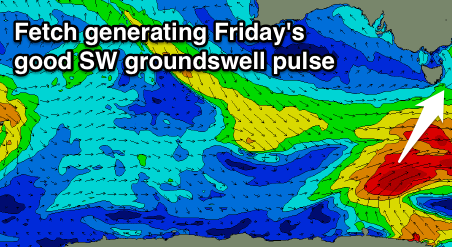
Currently a strong frontal system is directly south-west of us, aiming a fetch of SW gales through our western swell window.
This front will slowly push east, but an elongated fetch of W/SW gales will remain in our swell window followed by one final burst of S/SW gales in our southern swell window this evening.
 What should result is an initial pulse of W/SW groundswell for tomorrow to 2ft across Clifton, with a better pulse of SW groundswell for Friday to 2ft to likely 3ft, peaking through the middle of the day/afternoon before easing from 2ft Saturday morning, smaller Sunday.
Light morning NW winds are due both tomorrow and Friday mornings, shifting SW through the day while Saturday should offer morning N/NW winds ahead of S/SE sea breezes.
Sunday is looking a little dicey, but variable winds are most likely, increasing from the SE.
Next week onwards (Feb 8 onwards)
A temporary low point in swell activity is due Monday but we've got an upgrade in the W/SW swell due through Tuesday next week.
A weak polar frontal system moving in form the west is due to strengthen south-west of us, generating a broad fetch of strong to gale-force W/SW winds. A fun pulse of W/SW groundswell is due, peaking Tuesday morning to a good 2ft+ across Clifton, easing back through Wednesday.
Beyond this there's more persistent polar frontal activity on the cards for late week, but more on this Friday.

