Good period of small clean waves ahead
Southern Tasmania Surf Forecast by Craig Brokensha (issued Wednesday 13th January)
Best Days: Saturday morning tiny peelers, Sunday morning, Monday morning, Wednesday morning, Thursday morning
Recap
Onshore winds and an easing mix of average swells yesterday, while today a new SW swell filled in with workable clean 2ft sets early across Clifton before winds shifted back onshore.
This weekend and next week (Jan 16 – 22)
No real decent size is expected to be left into tomorrow morning across Clifton with ideal beginner waves to 1-1.5ft or so ahead of a late increase in new SW groundswell to 1-2ft.
Morning NW winds are expected before shifting SW and then S/SE into the afternoon.
The late increase in SW swell is being generated by a strong polar frontal progression currently to our south-west, with a peak due Sunday to 2ft across Clifton with N/NW offshores ahead of afternoon sea breezes.
 The swell should ease slowly through Monday from 1-2ft due to weaker background polar frontal activity with light morning NW winds and afternoon sea breezes.
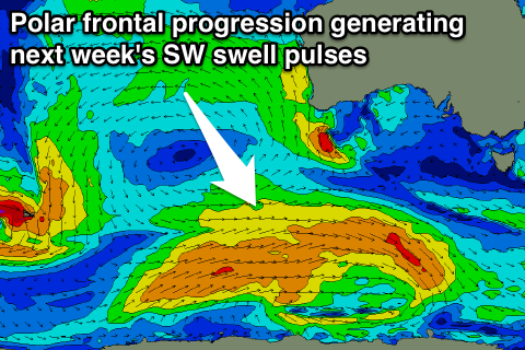
Longer term a strong but distant polar frontal progression firing up south-west of Western Australia should generate some good SW groundswell for Wednesday and Thursday.
An initial pre-frontal fetch of W/NW gales should produce a fun 2ft pulse for Wednesday morning, with a secondary increase for Thursday to 2ft+ (peaking through the afternoon) and then easing back into Friday.
A further pulse is due Saturday but we'll have another look at this on Monday. Have a great weekend!

