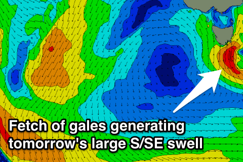
Large onshore S/SE swell Saturday, easing from the SE into next week
Southern Tasmania Surf Forecast by Craig Brokensha (issued Friday 28th August)
Best Days: Saturday protected spots
Recap
After Wednesday's strong kick in SW groundswell, yesterday provided more manageable 2-3ft waves with morning offshores. Today is poor with small amounts of swell and onshore winds, but an increase in size should be seen this afternoon.
This weekend and next week (Aug 29 – Sep 4)
Big/small/big/small.
 This has been the trend for the surf model forecasts for tomorrow over the past few days as the weather models struggled to place the position of the polar front that's currently pushing up into the state.
Now that we're actually right under the thing, we're set to see large stormy surf develop from late today as the front is pushed straight up and into us, instead of further west.
This will direct a fetch of S/SE gales into the south-east corner of the state, producing a large stormy S/SE swell for tomorrow in the 5-6ft range across Clifton but with strong to gale-force S/SE tending S'ly winds.
Through the weekend the low will broaden in scope as it combines with the remnants of an East Coast Low off the Southern NSW coast, directing a persistent fetch of strong to gale-force SE winds through our swell window tomorrow and Sunday, weakening through Monday and then gone by Tuesday.
This will produce moderate amounts of SE swell for Sunday in the 3-4ft range (larger at exposed spots to the SE), easing through Monday from 2-3ft or so.
Winds will remain poor though with a moderate to fresh S/SE breeze Sunday, light to moderate from the SE Monday. Come Tuesday variable breezes are due through the morning but with no real swell, fading from 1-2ft.
Longer term there's nothing significant on the cards until next weekend, but we'll have a closer look at this Monday. Have a great weekend!


Comments
Hi Craig,
Thanks for the forecast. I have a question that I was hoping you could help me with. I've asked a few people, but no one can really answer it for me.
Does the wind always blow parallel the ocean surface (ie horizontal)? Or does it sometimes have a vertical component to it (ie slightly inclined)?
Also, if the wind did have a slight incline it would transfer it's force more directly to the surface which would mean larger swell. But I feel this would also create more surface lumps and chop. I have a theory that when we get a bigger swell, it is because of the incline of the wind creating it rather than just being a function of the wind speed. This would also explain why big swells are always so raw, while long period swells are always on the smaller side. However, there is likely to be a point at which the 'wind incline' becomes too great and simply flattens the swell.
So I'm sure you know all about the effects of wind incline, but what I really want to know, is at what incline angle does the wind stop making swell, and begin to lessen the swell?
Thanks in advance and keep up the excellent work,
Greg
Hi Greg, no it's parallel with the ocean surface, with the frictional effects whipping up little capillary waves which then turn into small ripples and wind waves and then larger chops.
As the waves grow though, there are areas of low and high pressure that form around the troughs and crests which would then effect the wind inclination over the ocean surface but only slightly.
Great question though. And another thing, looking at the other plane of reference, wind around a low will slightly be aimed into a low pressure systems centre, and away from a high. Just one to keep handy when around the axis of a deep low.
I don't know Craig. How can you explain the tilting angle of a yacht in high wind if the wind is always parallel? For instance in the following picture.
http://image.yachtcharterfleet.com/yacht-reviews/sy-windfall-sailing-in-...
wouldn't that just be the drag of the yacht against the water, wind is travelling faster than the water will allow the hull to travel through the water, half of hull and keel underwater fighting pressure, wave chop and current to get moving
Photo shows a cross wind if my eye sight isn't playing up, yacht is always going to lean over in those conditions, hence why they run a big keel and lead ballast weight to stop from rolling over
Yes, there may be winds of a non-perfect horizontal angle with localised gradients, micro cells, swell and chop of the ocean, but my brain is telling me the only way you could get significant downward force would be if the ocean was somehow able to consume the wind within itself
Water is a hard barrier to oxygen, bubbles always float and break the surface so this makes it impossible to penetrate. Regardless of how great the wind force is, it will not penetrate into the ocean, yes it may push down the surface water level but only if vertical, everything else will run off horizontal once making contacting the waters surface, maybe....
Anyone got a spare jet engine and Lake Argyle in their backyard ?