Plenty of swell, cleanest over the weekend
Southern Tasmania Surf Forecast by Craig Brokensha (issued Wednesday 12th August)
Best Days: Later Thursday, Friday, Saturday, Sunday
Recap
An inconsistent W/SW groundswell held 1-2ft across Clifton yesterday morning, easing into the afternoon and becoming tiny today.
This week and weekend (Aug 13 - 16)
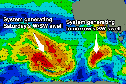
 Our good SW groundswell due tomorrow is still on track with a small but vigorous polar front currently pushing north-east towards us. This is due to cross the state this evening and early tomorrow, with a good SW groundswell filling in behind it.
Clifton should build to 3ft through the day but a pre-dawn W'ly is due to swing W/SW and persist most of the day. We may see winds tend back W/NW later in the day, so keep an eye on the local observations.
Friday will see the SW swell back to a smaller 2ft with offshore NW tending W'ly winds.
The weekend is looking great, with our good new W/SW groundswell on track as well. A broad and vigorous polar frontal progression is moving in from the south-eastern Indian Ocean and should produce a moderate sized W/SW groundswell for Saturday, building to 3ft on the sets across Clifton into the afternoon.
This swell should then ease back from a smaller 2-3ft Sunday. Winds are looking favourable with N/NW breezes Saturday and then strengthening NW tending W/NW winds Sunday.
Into Monday a strong new SW groundswell should build, produced by a strengthening polar frontal system pushing up towards us through the weekend.
This looks to produce good 3-4ft sets into the afternoon Monday if not a touch bigger but with poor S/SW winds as the front proper pushes through.
Behind this some further polar frontal activity in our southern swell window may be seen, but we'll have another look at this Friday.

