Tiny to small weekend, solid but tricky swell Tuesday, better Wednesday
Southern Tasmania Surf Forecast by Craig Brokensha (issued Friday 5th June)
Best Days: Sunday morning for small waves, protected spots Tuesday, Wednesday, Thursday
Recap
Tiny clean waves only really surfable for beginners the last couple of days.
 This weekend and next week (Jun 6 – 12)
Tomorrow is due to remain tiny and in the 1ft range but with favourable offshore winds.
A slight kick in small SW groundswell is still on the cards for Sunday generated by a small but tight polar low currently to our south-west.
This should provide 1-2ft sets most of Sunday as winds remain offshore from the N/NW.
Monday is due to start tiny and around 1ft, and a new acute W'ly swell due into the afternoon doesn't look as favourable with the frontal system currently generating it sticking too far north and out of our swell window.
Only a very inconsistent and small increase in size to 2ft is expected later in the day, so don't go planing around Monday for a surf.
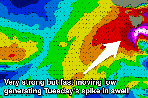
Into Tuesday though, the strongest of the frontal systems pushing through is still expected to generate a fetch of storm-force W/SW winds through our swell window... but... it's been pushed further north as well, and it will move really quickly through our swell window Monday evening.
This is worrying as the fetch will probably out run the swell its generating resulting in less size than otherwise would be seen.
I'd be really careful on the expectations with this well, with Tuesday likely to pulse up and down quickly, to be replaced by smaller and more consistent SW swell into the afternoon and Wednesday from a better fetch of SW gales on the tail of the front.
Clifton is likely to see 3-5ft sets at the swells peak early Tuesday morning before easing back to the 3ft range into the afternoon.
Wednesday should see a spike to 3-4ft though from a secondary better aligned front moving through during Tuesday evening, easing back to 2-3ft later in the afternoon and then down from 2ft Thursday.
Now, winds on Tuesday will be poor and strong from the W/SW, easing into the afternoon and possibly tending W/NW on dark. Wednesday looks clean early with a morning W/NW breeze, that may only tend W'ly into the afternoon. A return to better NW offshores is then due Thursday.
Longer term we've got a moderate sized S/SW groundswell on the cards for next weekend, generated by a strengthening polar low to our south during Friday. We'll have a closer look at this on Monday though. Have a great weekend!

