Strong new W/SW swell Sunday, easing into next week out of the S/SW
Southern Tasmania Surf Forecast by Craig Brokensha (issued Friday 29th May)
Best Days: Saturday, Sunday morning, early Monday, early Tuesday
Recap
Tiny leftovers yesterday as the SE groundswell faded, while today a tricky to forecast W/SW groundswell has come in a lot better than expected at dawn with clean 3ft sets. The swell should of held all day as winds remained offshore.
 This weekend and next week (May 30 – Jun 5)
Today's strong kick in W/SW groundswell should ease back through tomorrow, but Clifton should still see 3ft sets through the morning under fresh N/NW tending W/NW winds.
Sunday's strong kick in W/SW groundswell has been brought forward a touch with the vigorous polar frontal system generating it pushing in quicker than forecast on Wednesday.
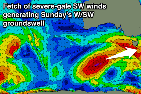
During tomorrow a fetch of severe-gale SW tending W/SW winds will be projected through our western swell window but on a path almost perpendicular to our Great Circle Path. This is a little concerning as it isn't ideal at all but we should still see it generate a strong W/SW groundswell, peaking through Sunday.
Clifton should come in at 3-4ft+ during its peak and winds look to be good through the morning and from the W/NW ahead of a strong onshore change at some stage during the day.
This change will be related to a secondary weaker fetch of strong to gale-force S/SW winds being projected up into us through Sunday and Monday, generating a moderate sized S/SW swell that should come in at 2-3ft though Monday before easing from 2ft or so Tuesday.
Winds are a little dicey but an early NW'ly is likely Monday ahead of a swing to the S/SW through the day and then similarly through Tuesday.
Longer term a small pulse of SW groundswell may be seen Wednesday but beyond this the westerly storm track will be focussed into WA and SA, which is too far north and unfavourable for us. Therefore make the most of the coming swells!

