Fun waves to continue, bigger later next week
Southern Tasmania Surf Forecast by Craig Brokensha (issued Monday 27th April)
Best Days: Thursday morning, Friday from mid-morning, Saturday morning, Thursday
Recap
Fun clean 1-2ft waves through yesterday, while today a new W/SW swell from a pre-frontal fetch of W/NW winds has provided more size to 2-3ft with good morning offshores.
This week and weekend (Apr 28 – May 3)
Today's swell is expected to drop back more to the 2ft range under NW winds ahead of possible weak SE sea breezes.
Friday morning is expected to start slow with 1-2ft leftovers, but a new SW groundswell should pulse through the morning, reaching 2ft to possibly 3ft across Clifton.
This is being made by a vigorous polar low to our south-west, generating an unfavourable fetch of severe-gale to storm-force W/NW winds. The strength of the system should overcome the unfavourable direction. Winds should be good for most of the day with a N/NE tending N/NW breeze.
The swell will drop considerably into Saturday from a smaller 2ft on the sets with persistent offshore N/NW winds, while Sunday will be tiny and clean.
 Next week onwards (May 4 onwards)
A vigorous polar frontal progression firing up towards WA over the coming days will be too far away and out of our prime swell window to generate anything but a very inconsistent 1-2ft wave through Tuesday when it arrives.
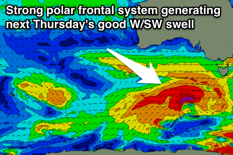
Of greater significance is a couple of better aligned polar frontal systems firing up in our swell window through next week as a strong node of the Long Wave Trough moves in from the west.
This should hopefully produce a better W/SW groundswell for Thursday in the 3ft+ range possibly followed by a secondary swell over the weekend. More on this Friday though.

