Easing surf ahead of a strong swell Sunday
Southern Tasmania Surf Forecast by Craig Brokensha (issued Monday 13th April)
Best Days: Tuesday, Wednesday morning, Friday, Saturday morning, Sunday morning
Recap
Small clean 1-2ft waves Saturday while the beginnings of a large new S/SW groundswell were evident Sunday morning to 3-4ft but with onshore winds. The swell kicked strongly late in the day as winds favoured protected locations. This morning the swell was still solid enough to offer runners in protected spots but a drop in size has since been seen with unfavourable S/SE sea breezes.
 This week (Apr 14 - 17)
Today's large S'ly groundswell should continue to ease over the coming days, dropping from 3ft tomorrow out of the S/SE, back to a smaller 1-2ft Wednesday morning.
Winds will be good and offshore from the N/NW tomorrow morning, tending N/NE into the afternoon and then Wednesday should see all day offshore N/NW winds.
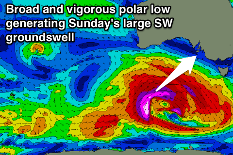
Tiny surf is then due into Thursday while a new mix of W/SW swellsl are due to fill in Friday. The first swell will be generated by a vigorous polar frontal system firing up to the south-west of WA tomorrow, generating a fetch of severe-gale pre-frontal W/NW winds followed by a secondary fetch of W/SW winds.
A strong and inconsistent W/SW groundswell should be produced by this system, building through Friday towards a peak into the afternoon to an inconsistent 2-3ft. A front shedding off this polar low and pushing below us Thursday evening though will generate a local increase in W/SW swell for the morning to 2ft in any case. Winds should be favourable and offshore from the N/NW all day.
This weekend onwards (Apr 18 onwards)
Friday's swell is due to ease back from 2-3ft Saturday morning across Clifton, but the strongest and largest of all the polar lows moving in from the west this week is due to develop a larger W/SW groundswell for later Saturday and Sunday morning.
This low is forecast to generate a fetch of storm-force W/SW winds through our swell window while tracking towards us this week. Clifton should build to 3ft+ late in the day and peak Sunday morning in the 4-5ft range. Winds look to be W/NW to SW, but we'll have a closer look at this on Wednesday.

