Easing swell tomorrow, better pulses from Monday afternoon
Southern Tasmania Surf Forecast by Craig Brokensha (issued Friday 20th February)
Best Days: Early Saturday, Tuesday morning, Wednesday morning
Recap
A slight kick in swell was seen yesterday with early favourable winds, while the swell was hanging around a tiny 1-1.5ft this morning with early variable winds. A strong onshore change has since moved through though, spoiling a new SW groundswell that's on the build.
 This weekend and next week (Feb 21 - 27)
This afternoon's kick in SW groundswell should reach a good 2ft ahead of a peak overnight and then slow drop through tomorrow from 1-2ft. Winds will be good early and from the N'th before kicking around to a fresh NE'ly through the day.
Come Sunday there isn't due to be any real size left but conditions will be great with a N/NW'ly ahead of a late onshore change.
Our good pulses of inconsistent long-range W/SW groundswell are still on track for Monday afternoon and Tuesday.
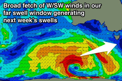
The intense and broad polar low linked to Monday afternoon's pulse has already formed south-southwest of WA with a fetch of gale to severe-gale W/SW winds being generated in our far swell window. The low will move slightly east overnight before weakening tomorrow morning leaving an inconsistent W/SW groundswell to travel towards us.
This swell should build to an inconsistent 2ft+ during Monday afternoon but at the same time a gusty W/SW change is due to move through creating poor conditions.
The change however will be linked to a weaker front spawning off the low, projecting a fetch of strong W/SW winds through our swell window Sunday and Monday.
This should generate a more consistent W/SW swell to a similar 2ft+ through all of Tuesday and Wednesday morning before easing into the end of the week. There is the chance for 3ft sets through this period due to the large and broad nature of the low generating the swell, but they'll be infrequent.
Winds are looking good for a period Tuesday morning and from the NW ahead of a shift to the SW mid-late morning, while Wednesday also looks clean with a N/NW'ly ahead of NE breezes.
Longer term we may see a short-range SW swell later in the week as a deepening polar low pushes in from the west, but we'll discuss this Monday. Have a great weekend!

