Swell Friday with onshores, easing over weekend, better swell arriving Monday
Southern Tasmania Surf Forecast by Craig Brokensha (issued Wednesday 18th February)
Best Days: Saturday morning, Monday afternoon, early Tuesday, Wednesday morning
Recap
No surf to speak of with tiny to flat conditions and poor winds.
This week and weekend (Feb 19 - 22)
A small and very inconsistent SW groundswell pulse is due through the day tomorrow, rising from a tiny 1ft to 1-2ft through the middle of the day as early N'ly winds give into a freshening NE'ly.
A better pulse of SW groundswell is due into Friday afternoon though generated by a stronger polar low pushing further east than the one responsible for tomorrow's swell. Clifton should kick to a good 2ft through the day with the chance of the odd bigger set but winds will be poor as a surface trough pushes through around dawn, bringing fresh S/SW tending S/SE winds.
Saturday will be better with an easing swell from 1-2ft under N/NE winds. Sunday will be perfect but tiny and only for beginners with a N/NW offshore ahead of sea breezes.
 Monday onwards (Feb 23 onwards)
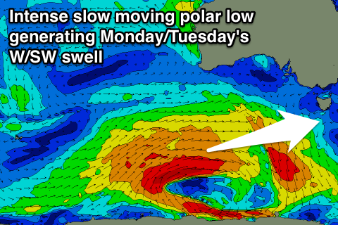
As touched on last update, a strengthening node (peak) of the Long Wave Trough is forecast to move in from the west later this week, reaching a peak in intensity as it stalls over the Bight on Sunday evening.
With this development we'll see a vigorous polar low developing south-west of WA in a similar position to the system generating Friday's swell, with the low expected to stall, aiming a persistent and broad fetch of gale to severe-gale W/SW winds through our far swell window followed by a weaker fetch of W/SW winds pushing towards and across us Monday evening.
This should generate two pulses of W/SW groundswell, the first being the least consistent and building through Monday afternoon to 2-3ft by dark, with a secondary pulse for Tuesday to a similar and more consistent 2-3ft.
Winds should be offshore from the NW right until mid-late Monday afternoon when a W/SW change is due, but Tuesday morning should see winds tending back to the W/NW through the morning ahead of a SW'ly.
After this swell event the surf will back away with nothing major until possibly the next weekend. But more on this Friday.

