Average tomorrow, good Friday, fading Saturday
Southern Tasmania Forecast (issued Wednesday 15th October)
Best Days: Friday morning, Saturday, Tuesday, Wednesday morning
Recap
The swell remained solid and in the 3ft range yesterday morning before easing back through the afternoon and back to 1-2ft this morning.
This week (Oct 15 - 17)
 A good pulse of SW groundswell tomorrow is still on track, building to 2ft+ through the day but onshore winds look to still be on the cards with a W/NW'ly at 5am expected to give way to a S/SW change shortly after, so leave it tomorrow.
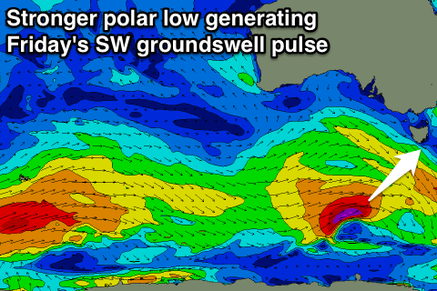
Friday's reinforcing SW groundswell has been upgraded, with the front generating it now forming into a stronger polar low, aiming a fetch of severe-gale SW winds towards us today.
This swell should offer easy 3ft sets into Friday morning before easing into the afternoon and further from 2ft+ Saturday morning. Winds will be a slight problem still Friday morning, but we're likely to see an early light NW breeze around Clifton before SE sea breezes kick in.
Saturday will be nice and clean all day with the easing swell and N/NW tending N'ly breeze.
This weekend onwards (Oct 18 onwards)
The next increase in swell is due Monday afternoon, generated along the polar shelf to our south-west as a weakening polar front pushing towards WA re-strengthens. This should produce a fun 2ft+ of swell for Monday, arriving through the morning but easing onshores will create average conditions, before easing slowly into Tuesday. Background levels of swell should then keep small 1-2ft waves kicking through the rest of the week.

