Good Thursday, excellent Friday
Southern Tasmania Forecast (issued Wednesday 6th Aug)
Best Days: Thursday, Friday
Recap
A solid increase in W/SW groundswell was seen through yesterday with a few options in protected spots with the westerly winds. Today the swell has dropped back temporarily to 2-3ft but we should of seen a late kick in size this afternoon from another vigorous front passing under us.
This week through Monday (Aug 7 - 11)
The vigorous front pushing across us currently is generating a fetch of severe-gale W/NW winds tending W/SW winds through our western swell window.
This should keep 3-4ft sets hitting Clifton through tomorrow and winds will weaken but remain from the W/NW favouring slightly protected locations.
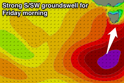
Friday is still looking excellent as the stronger S/SW groundswell fills in and peaks through the morning.
This swell is being generated on the back of the front pushing through today with a fetch of severe-gale SW wins being projected up towards New Zealand from below us, through our southern swell window.
 This swell should come in at a solid 3-4ft+ during the early morning before easing steadily as a result of the front pushing off quickly to the east.
Winds will be offshore all day from the N/NW-NW creating excellent conditions.
Saturday isn't expected to see much size above 1-2ft but another vigorous polar front pushing up from our south-west into us on Saturday should produce a strong SW groundswell for Sunday. This will be mixed with some large long-range W/SW groundswell energy as well and should come in at 3-5ft Sunday afternoon with more size to 4-5ft likely Monday morning.
Winds will unfortunately swing strong onshore from the SW Sunday afternoon and persist from the S/SW Monday creating poor conditions.
Next Tuesday onwards (Aug 12 onwards)
Monday's swell should ease off into Tuesday and Wednesday as winds improve on the former but go dicey from the S/SE on the later. Beyond this there's nothing major on the cards so make the most of the coming period.

