Good later Sunday, best Monday
Southern Tasmania Forecast (issued Friday 18th Jul)
Best Days: Saturday morning for keen surfers, Sunday afternoon, Monday, Tuesday, Wednesday
Recap
Yesterday was poor with strengthening onshore winds and a new W/SW groundswell that then was hard to distinguish under a building S/SE windswell.
This windswell has peaked this morning to a poor 3-4ft across Clifton but not quite big enough for more protected locations to get going. The low generating this swell should of moved to the east a touch and out of our swell window this evening, resulting in a drop in size.
This weekend onwards (Jul 19 onwards)
Today's stormy S'ly windswell will ease further into tomorrow, mixed in with a long-range W/SW groundswell coming in at 1-2ft. Winds should improve but may still be dicey and from the West early tomorrow before swinging W/NW through the morning.
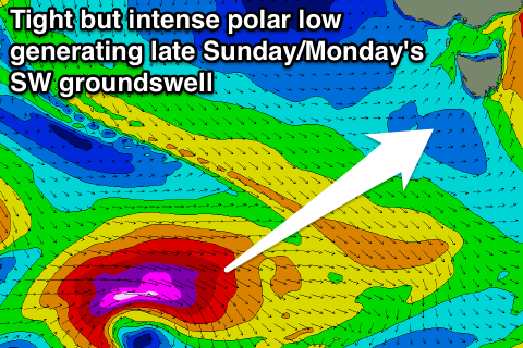
 Sunday's late kick in swell is still on track with a tight and intense polar low due to generate a fetch of severe-gale to storm-force W/SW winds through our swell window today. The swell from this system should arrive later Sunday and build to 3ft by dark before easing from a similar 3ft Monday morning.
Winds look good Sunday and from the W/NW for most of the day while Monday looks excellent as the swell drops away under N/NE tending variable winds.
A small reinforcing swell for Wednesday should keep inconsistent 1-2ft sets hitting Clifton before slowly tailing off into the end of the week. Conditions will be great all week with generally offshore winds from the N'th.
Longer term there's nothing too major on the cards at this stage but we'll review this Monday. Have a great weekend!

