Great Thursday, funky S/SE swells over the weekend and Monday
Southern Tasmania Forecast (issued Wednesday 18th June)
Best Days: Thursday, early Friday, Saturday at exposed spots
Recap
The surf's been tiny across the coast the last day or so but ideal for beginners.
This week (Jun 18 - 20)
There's been no real change to the good pulse of SW groundswell due tomorrow morning with Clifton expected to offer good 3ft waves through the morning before easing later in the day. Winds should be great all day, swinging offshore from the NW during the morning to a more variable breeze from the N'th into the afternoon.
Friday isn't expected to offer much size above 1-2ft but conditions will remain clean with a persistent NW'ly.
This weekend onwards (Jun 16 onwards)
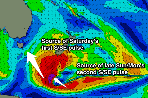
The rare S/SE groundswell due over the weekend is still on track, but it's moved around a little and we'll probably see a couple of pulses ebbing and fading through the weekend and Monday.
 The source of this swell is a polar low forming under New Zealand this evening, with an initial fetch of severe-gale S/SE winds generating an initial pulse of S/SE groundswell for Saturday.
Behind this though an additional fetch of severe-gale E/SE winds should generate an additional pulse for later Sunday and Monday morning.
The first pulse should offer inconsistent 1-2ft waves across Clifton Saturday before easing overnight leaving tiny waves for Sunday. The additional pulse should arrive later Sunday, pulsing back to 1-2ft before easing from 1-2ft or so Monday.
Spots further down the South Arm and more exposed to the south-east should see a touch more size. Winds Saturday should swing from a light NW'ly around to the NE through the afternoon, with NW tending fresh N/NE winds Sunday ahead of stronger N/NE tending N/NW winds Monday.
Longer term we could see a medium sized but short-lived pulse of SW groundswell next Tuesday/Wednesday as a mid-latitude front moving in from the west deepens significantly while feeding off a deep pool of cold air in the upper atmosphere.
The models are still a little divergent on the strength and positioning of this swell, but check back here on Friday for the latest on this.

