Not much on offer, though a few south swells are due next week

South-east Queensland and Northern NSW Surf Forecast by Ben Matson (issued Fri 23rd August)
Features of the Forecast (tl;dr)
- Small average weekend, not worth worrying about
- Small flush of south swell late Tues (MNC) and Wed (FNNSW), tiny in SE Qld
- Better pulse of south swell late Thurs (MNC) and Fri (FNNSW), tiny in SE Qld
- More southerly pulses for the foreseeable future, i.e. extended run of small surf in SE Qld
Recap
Easing S/SE swells on Thursday managed 2-3ft sets at south facing beaches south of Byron, though the surf was much smaller elsewhere and throughout SE Qld. Wave heights are even smaller today. Fresh northerly winds on Thursday swung SW early this morning and is now moderate E’ly across most regions.
This weekend (Aug 24-25)
The weekend looks pretty average.
Light winds are expected in most areas on Saturday morning, though we’ll see an early shift to the north along the Mid North Coast, extending to northern regions (including SE Qld) by the afternoon. This will create bumpy conditions at most beaches as the day progresses, though sheltered northern corners should offer some protection.
Moderate N/NW winds are then expected on Sunday, tending NW across the Mid North Coast.
As for surf, we’ve got a few small pulses of flukey south swell on the way, generated by poorly aligned fronts sliding south of Tasmania at the moment. The first will glance the Northern NSW region on Saturday and the second is due Sunday, but I’m doubtful that we’ll see much more than a stray 1-2ft wave at south swell magnets south of Byron both days. Elsewhere will be much smaller.
The local freshening northerlies may also generate some low quality windswell but it’s not worth getting too excited about.
A minor undercurrent of trade swell will probably keep remaining beaches from becoming flat too, though no great size is likely (this includes a minor intensification of a fetch in the lee of today’s change, due east of Ballina this afternoon, which may provide 1-2ft sets north from here into SE Qld on Saturday).
All in all, it’s really not looking too flash though you may get lucky if you can find an ideal small wave bank setup that is offering shelter from the developing northerly flow.
Next week (Aug 26 onwards)
First up - our eastern swell window has a few features to discuss, though ultimately there won’t be much surf as a result.
A weak trough developing west of Fiji over the weekend is expected to extend a trade flow to its east, but no major strength is modeled and thus, it’s unlikely we’ll see much surf from it - maybe some slow 1-2t sets early/mid next week.
Additionally, a slightly stronger tropical depression may spin up south of Tonga on Mon/Tues, but again, the relevant fetch inside our swell window looks to be thin and brief so surf potential isn’t high (for the end of the week). We’ll reevaluate on Monday though.
Otherwise, a strong cold front will cross Victoria on Sunday afternoon, and we’ll see W/SW gales exiting eastern Bass Strait on Monday (see below).
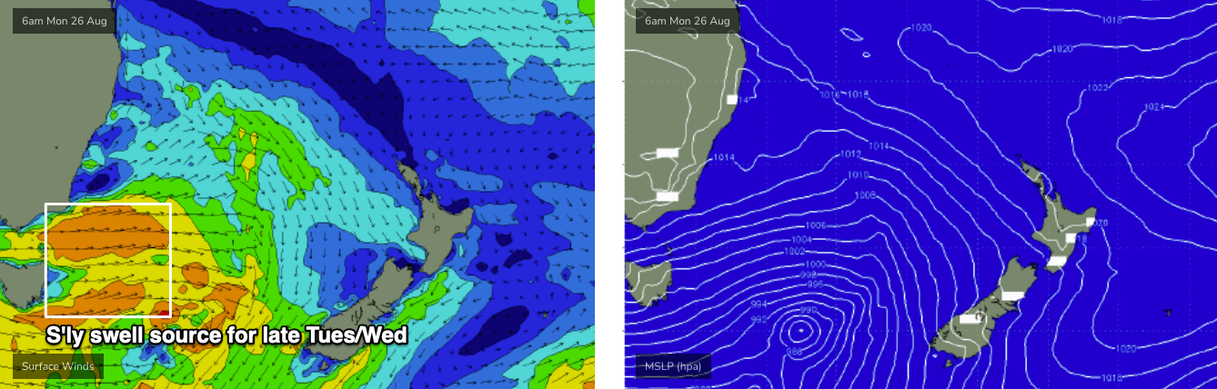
This should give rise to a brief flush of south swell for Tuesday afternoon (Mid North Coast) and Wednesday morning (Far North Coast), reaching 2-3ft+ at a handful of reliable south facing beaches south of Byron. SE Qld won’t see much size though and beaches not open to the south will be much smaller.
There is also a risk of northerlies through this period, but we’ll take a closer look at the specs on Monday.
A similar, though stronger frontal progression is then expected across Victoria on Wednesday which should provide a slightly bigger round of acute south swell for very late Thursday (Mid North Coast) and Friday (Far Northern NSW), with a stronger following front trailing behind generating incrementally bigger waves into the weekend.
It’s still early days but we could pick up 3-4ft+ sets at south facing beaches south of Byron by the end of the week.
Again, northerlies will remain a risk right through this period (Brisbane looking at a forecast of 32 degrees on Wed/Thurs... in late August!) so even if we do see some swell across the region, quality may be a problem at many coasts.
The long term outlook maintains similarly strong fronts across SE Australia which should provide intermittent small to medium sized south swells for Northern NSW for the foreseeable future.
Have a great weekend, see you Monday!
Comments
Difficult to believe it’s August. Staring down another week of pre spring northerlies.
We're less than a month from the Equinox, seen plenty of N'ly episodes late Aug before.
I think this feels a bit shocking because of so many La Niña springs.
Hopefully that influence will assert itself at some point.
But yes, looks like lots and lots of N'lies ahead.
Was about as tiny and weak as I've seen it in ages today.
Yeah for sure re: northerlies.
Just the flick of the warm switch has surprised me.
Did we kind of miss the Ekka westerlies?
Last day of winter forecast to be 35 degrees in Brisbane, 30 degrees at the coast.
Abysmal.
Surfed in boardies up the North Coast on the weekend! Middle of winter, wtf!
I dare you to try that next week!
Ha.
Well done finding a surfable wave! I heard there were a couple on the open stretches satdy morning high tide.
Cheers, yeah fun 2ft peaks.
excluding a few days and of course mornings its been possible to surf in boardies the entire winter on the GC
Now that footy season is over on Saturday morning, found a high tide bank & pushed my 10yo onto a 1000 waves.
My board stayed on the sand.
Stoke levels were very high for all!
Took your tip Freeride and picked up a few flatties on the weekend.