Looking good for longer term
South-east Queensland and Northern NSW Surf Forecast by James Casey (issued Wednesday 19th May)
Best Days: Easing S swell south of border Thursday, late Tuesday/Wednesday onwards with E swell
Outlook:
- S Swell to fade into Thursday lingering around 3-4ft early smaller late (south of border)
- SE QLD will remain around 2ft as limited swell gets around the corner, relying moe on an E/SE windswell
- Another smaller S swell looks to fill in for the weekend (south of the border) while SE QLD continues to rely on a SE windswell around 2-3ft for Goldy 3ft for Sunny Coast
- New E swell set to fill in from late Tuesday onwards next week with a widespread 5-6ft initially and potentially bigger down the track
Recap
Yesterday we had a new mid period S swell in the 3ft range, best for south of the border. SE QLD didn’t see much of the size staying in that 1-2ft range and smaller. Winds were offshore out of the W/SW early but tended more out of the S to SE as the day went on.
Today we have slightly bigger conditions for the Goldy and Sunny Coast but it’s still not over 2ft. S/SW winds early kept conditions clean enough. South of the border the swell remained in that 3-4ft range, a little bigger for the MNC. Winds were lighter and more W to SW south of the border.
Later this week
S swell will continue for the remainder of the week providing decent options south of the border. Meanwhile SE QLD will have an E/SE windswell that’ll wrap around the corner better than the S swell.
South of the border the swell will remain around 3-4ft for Thursday but begin to ease throughout the day. SE QLD will see waves around the 2ft mark at exposed spots, smaller elsewhere with a weak windswell not offering much in terms of size. Winds will start out light and offshore tending stronger and SE for the Goldy and Sunny Coasts and becoming more light and variable for N NSW and NE for the MNC.
Friday will see the last of the S swell easing to the 1-2ft mark south of the border, with a weak windswell SE QLD will remain small too. Winds will be out of the SW early but tend more SE and strengthen later in the day.
The weekend
A SE windswell will create most of the energy for the weekend for SE QLD while another weaker S swell moves up the coast better south of the border. This swell won’t be as well aimed so only expect it at S swell magnets. An E/SE windswell will fill in better across the region due to the persistent E/SE winds driven by a ridge in the Tasman, but it won’t pack much punch. Only really 2-3ft waves across the region, a little bigger for the Sunny Coast up around 3ft.
Winds will be SW early but tend more SE as the day goes on for both Saturday and Sunday.
Next week
The E/SE windswell will continue to provide small waves on Monday with SW winds early tending more SE into the afternoon. 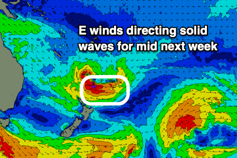
A more powerful E swell is set to fill in late Tuesday/Wednesday. This swell will build thanks to E winds funnelling into a region of low pressure as it pinches the ridge of high pressure. It will intensify into a low and shift south towards the North Island with strong E winds funneling into the western flank of the low. These winds will direct a decent E swell towards our coast with a widespread 5-6ft expected across the east coast.
Winds will be S/SW early for SE QLD, more W south of the border before a light onshore flow for the afternoon, more SE for SE QLD and more NE for the MNC. Wednesday will see light offshore winds early tending more E/NE but remaining light into the afternoon.
Let’s keep an eye on it as it could provide a good week of waves.
Comments
GFS has been super horny for that low setting up on top of NZ. Pretty much dream scenario on the latest run, but GFS does tend to overfroth on the long terms. Fingers crossed.
Love it when the models get super horny ;-)
EC is also playing ball to a certain extent (noting the long term duration of the forecast low).
I can't quite believe the way GFS resolves that low, so I'm going to ignore it.
while at the same time making sure all the boards in the quiv. are ready to rumble.
Yeah the GFS tracking of it above north of NZ seems out of kilter with what they normally do.
thats exactly what I'm thinking Don.
Latest run is ridiculous, too good to be true.
normally when GFS spazzes out and produces a chart too good to be true it ends up backing down.
we'll see.
What’s the prediction predicting?
Ben, any chance getting the kings cam restarted
doesnt this question get asked every week?
We replaced the router and UPS yesterday but the cam is wigging out.. not sure what's wrong but I'm going to upgrade the whole shebang ASAP. Sounds like the cam is on the fritz.
Unfortunately, we don't have any spare cameras around at the moment.. we are still waiting on a major hardware delivery (been three months already.. "it'll be there soon" they tell us) so I can't swap it out until that arrives.
Sorry!
Damn it, worried it might have been something more this time
Thanks for giving it the kickstarts
Surely you know what conditions work there by now spud, it ain't hard mate. Pretty much all you need...
https://wind.willyweather.com.au/qld/sunshine-coast/caloundra.html
Throw this in if you really want...
https://www.qld.gov.au/environment/coasts-waterways/beach/monitoring/wav...
I know Sprout, I check all the other data as well but it's not as good as the camera.
Just visualise small surf, and an infestation of SUP's.
Yeah fair enough mate. I think tiger nailed it haha.
Or pumping surf and an infestation of kooks.
True, but it's the only working cam south of Alex on the SC
EC progging the most likely scenario which is the fcking sheep shagging isle dissects the fetch yet again!!!
Bloody imagine if it wasn’t there
But I wonder if NZ has anything to do with the low stalling there for so long ?
It's def stronger because of NZ, squeezing the low.
land is an impediment to wind speeds.
Yes, but broader scale I see it influencing the central pressure and making it stronger than it otherwise would be with the fetch between the centre of the low and land mass being stronger as it's squeezed/funneled past/against the land mass?
useless as tits on a bull if the fetch is behind that land mass though, which is the problem.
or if the fetch is bisected by the land mass, which is also a constant problem.
Yes, but this one looks the goods IMO
models still flip flopping a bit but yeah, we'll get something .
possibly something very good.
not this old chestnut again.
we lose a lot of quality groundswell from the Eastern quadrant because of the north Island, no question.
I wasn't gonna go there.. but.. ha
The way NZ courts foreign ownership of its real estate, Aussie surfers could just crowdfund and buy the whole island outright then shift it at our leisure.
The question then is ....Where do we move it for maximum gain?
I reckon 500-1000km south and she'll be right!
Another half million years or so and it won't be there anyway.... ;)
EC, GFS and UKMO models resolve the low very similarly today. EC a tad farther west.
EC a tad further south also which is a problem. Remember this low actually doesn’t have to travel too far south from forecast location to actually halve the swell heights or worse still actually completely block the swell due to NZ. Still can go either way and IMO based on history I see NZ stuffing this one. Agree we’ll get something from the earlier stages. Just not that confident on the latter stage at this stage.
me too Don.
history counsels caution.
Any comments regarding seeing a system like this in May? Looks like a classic late summer set up, but May!
I’m tending to look to systems south at this time of year so perhaps it’s more common than I think, but late May?
Craig, Freeride, Donw?
no, May is common for this type of low.
normally see something like this through autumn/early winter.
The infamous July 2001 swell was analogous.
Almost a year to the day
my bad, just looked at the bom archive and saw that was an ECL
Big low/E swell in July 2019 too. Thank you very much.
Perhaps this system will wash away the pesky bit of NZ north of Auckland, thus increasing our eastern swell window incrementally.
Sunny coast could do very well out of this, thank you very much! and hows that beast of a low progged for next weekend....