Average outlook for the short term, but there's plenty of potential for next week and beyond

South-east Queensland and Northern NSW Surf Forecast by Ben Matson (issued Friday 3rd January)
Best Days: Early Sat at exposed beaches before the wind picks up. Sunday has a possible small window of opportunity across parts of the MNC. Mon/Tues will see flukey but potentially good action at south swell magnets south of Byron. Later next week has a trade swell for SE Qld and Far Northern NSW.
Recap: Our last round of cyclone swell from TC Sansai came in at the bottom end of forecast expectations, with size peaking around 4ft+ on Thursday at exposed beaches, and smaller surf elsewhere. Morning winds were noticeably lighter across the Mid North Coast than the preceding days, but came up gusty from the NE into the afternoon. Light variable winds and moderate sea breezes were seen elsewhere. We’ve seen size back to the 3ft mark today, though still with plenty of power, and early light winds are now gusting 28kts from the NE at Coffs Harbour, though the sea breeze is less than half the strength across SE Qld.


Tweed Coast looking nice yesterday arvo
This weekend (Jan 4-5)
With surf size being a little smaller than expected for the last few days, and the only swell source for the weekend being the tail end of the TC Sansai event, we need to recalibrate our size expectations across the region.
Early Saturday morning may see some stray 2-3ft sets across exposed beaches, before it abates to around 2ft, and then 1-2ft on Sunday. Expect slightly smaller surf across the Mid North Coast.
Freshening N’ly winds will create problems (again!) across much of Northern NSW on Saturday, especially the Mid North Coast, though SE Qld (and possibly the Far North Coast) will see a reasonable period of light variable winds around dawn.
A S’ly change will push up the Southern NSW coast overnight Saturday, and it’s expected to nose into the Lower Mid North Coast around dawn, reaching Port Mac before 8am and possibly Coffs mid-late morning before it dissipates. Elsewhere, expect freshening northerly winds at some point Sunday morning, abating through the middle of the day as the trough approaches, ahead of a light to moderate NE sea breeze.
The Mid North Coast should pick up 2-3ft of peaky short range S’ly swell after lunch on Sunday (in the lee of the change) but quality won’t be high as it’s likely to still be quite wind influenced. There’s an outside chance that some locations around Coffs may not see much strength from the S’ly change, but may also pick up the new swell - so keep an eye out for that.
Otherwise keep your expectations low.
Next week (Jan 6 onwards)
The impressive mid-latitude low I was discussing all last week is still looking, well, impressive.
It’s expected to ‘bomb’ over the weekend (meaning a central pressure drop of more than 24hPa in 24 hours) but the core fetch will be aimed outside of our swell window (see below).
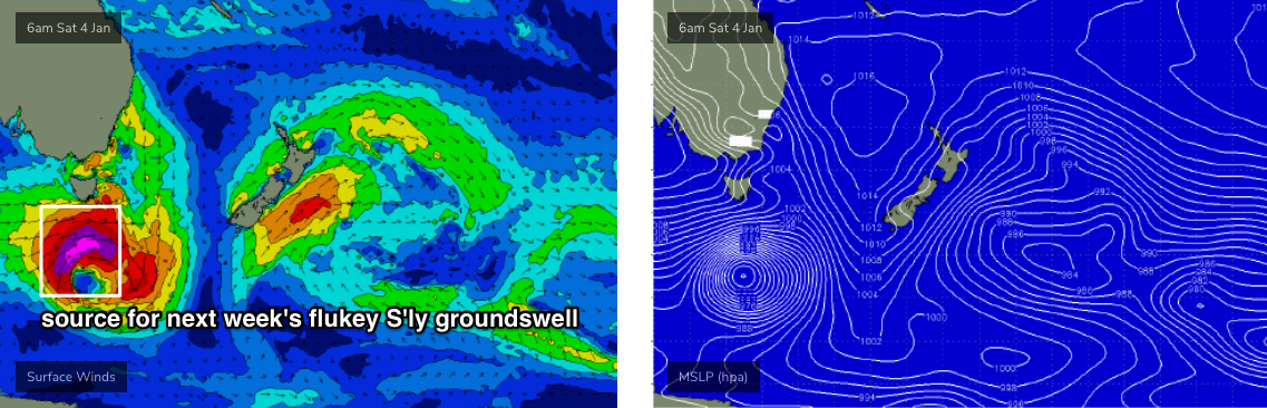
The low will pass across our Great Circle paths whilst on a steady E/SE trajectory, which isn’t favourable for swell production - but by this time there’ll be a long, broad expanse of SW winds that should generate some flukey south swell for our region.
Initially, Monday is looking to see 2-3ft of peaky leftover short range SE swell across the Mid North Coast (smaller north from Coffs/Yamba, and not much at all in SE Qld), originating from the bottom of Sunday’s stalled trough. This will swing the winds around to a light NE as the trough dissipates and a high moves into the Tasman Sea, but speeds shouldn’t be too strong and there’ll be pockets of light variable winds right up and down the coast. In fact much of the week is looking to see reasonable conditions under a weak local synoptic pattern.
Estimating surf size from the associated S’ly groundswell is tricky, because the energy will probably just glance the coast, and not affect many locations at all. So, expect a wide range in size between very little (or more accurately, a greater influence of short range SE swell on Monday), and up between 3ft to almost 5ft at south swell magnets south of Byron.
There’ll be a couple of swells pushing through at various times between Monday morning and Wednesday morning, with late Monday (Mid North Coast) and early Tues (everywhere else) looking the most promising at this stage. But, keep your expectations low, as it’s not a high confidence event.
As for SE Qld, south facing beaches and exposed northern ends (mainly on the Gold Coast) may pick up stray 2ft+ sets if we’re lucky, but everywhere else is expected to be much smaller, and not really very exciting. Expect a little less size on the Sunshine Coast.
Looking further ahead, and we’ll see easing S’ly swells from Wednesday onwards. The only other swell source standing out right now is a strengthening trade flow through the Coral Sea from mid-week onwards that will slowly build peaky E’ly swells across the Gold and Sunshine Coast (and down to about Ballina) later next week and into the weekend. No major size is likely but se waves should push 3ft by the end of the week.
There are also some suggestions for a significant Tasman Low the following week but this is a long time away so I wouldn’t put too much planning time around it yet. However it’ll be one to watch during next week’s notes.
Have a great weekend, see you Monday!
Comments
Gee a significant Tasman low with plenty of rain would be good for the fires, let’s hope so.
Actually, it'd be potentially bad - lots of wind, not much land based precip - unlike an ECL which has high coastal rainfall (though also very strong winds).
A deep, slow moving inland trough adjacent the coast with a large moisture infeed from a NW cloudband would be very welcome right about now.
I can’t remember the last time we had an East coast Low..........was there a single one in 2019?
Oh ok well here’s hoping for that to happen in a big way very soon for our south coast mates.
This cyclone swell has been nicely persistent. Still producing good waves in SE Qld/FNNSW this morning.


Hope someone found a bank.
Stellar conditions but a steady run of closeouts before the northerly did me in this morning.
looks like the S'ly change lost its legs between Coffs and Yamba.
This looks rather promising:
drought breaker if it comes off.
When’s that forecast to happen ?
Sheesh
it's on the 180hr GFS .
generalised pattern looking better re: position of the high in the Tasman and Tradewind flows in the northern Tasman, central/south CS
Had a look at the charts just now, seems to have changed a bit. Is it looking less likely for a decent drop now?
WA cyclone will be playing havoc with the forecast models so I’d be taking any long range charts with a grain of salt.
But in saying that the long range charts are looking WAY more Summerish than what we’ve seen anything remotely looking like over the last two months so bring on a semi stationary Tasman high with some slow moving areas of low pressure on we northern flank I say!!!
And thank Fck we’ve got some winds coming with the letter “S” in them!!
yep, finally a high at Tasmanian latitudes.
Models chopping and changing at the mo, which is often the case when dealing with tropical moisture and energy. Latest few GFS runs have been hinting at several TCs forming. Here's Sun 19th:
As I said. Anything outside about 4-5 days forecasting time I’d be taking with a considerable grain of salt.