Great waves on the radar for early next week

South-east Queensland and Northern NSW Surf Forecast by Ben Matson (issued Wednesday 28th August)
Best Days: Sat/Sun: small waves at outer Goldy points, and protected spots in Northern NSW. Mon/Tues: fun E'ly swells with light winds. Wed onwards: extended run of moderate S'ly swells for Northern NSW, holding into the following week. Lingering E'ly swells too.
Recap: Wave heights have been very small in SE Qld, but Northern NSW (in particular the Mid North Coast) has seen a small, peaky combo of south and east swells. Winds have been generally variable.
This week (August 29 - 30)
Today’s Forecaster Notes are brought to you by Rip Curl
A vigorous front will push across Southern NSW tomorrow morning, driving winds around to the south at strength. It’ll nose into Northern NSW during the afternoon but will stall in a troughy configuration off the coast, leading to a three-day run of fresh southerly winds along the coastal margin of all areas between Seal Rocks and the Sunshine Coast.
Ahead of the change, winds will be light and variable though with very little surf on offer there won’t be much to get excited about - just a few stray southerly sets at south facing beaches south of Byron.
Behind the change, local windswells will build across the region - mainly into Friday - but for the most part, exposed locations in Northern NSW (picking up the most size, say 3-4ft+) will be wind affected, and there won’t be enough size for sheltered locations - including the outer SE Qld points. As such, keep your expectations low for the next few days.
The next few days will also see a small underlying S’ly groundswell sourced from strong fronts below Tasmania over the last few days. Aside from Thursday morning, which may show some peaky options ahead of the change, it’ll be hard to detect these sets below Friday’s windswell noise.
This weekend (Aug 31 - Sep 1)
Unfortunately, there's been a downgrade for the weekend's surf potential, with the inbound E'ly swell being delayed until early next week.
Fresh southerly winds will create problems at exposed beaches all weekend, but we’ll see slowly building surf across protected locations.
Friday’s trough off the Northern NSW coast will initially maintain a strong SE fetch aimed towards Northern NSW. This should generate bumpy, wind affected 4-5ft, maybe 4-6ft surf at south facing beaches south of Byron on Saturday before size eases into Sunday. Protected locations will be much smaller but they’ll have the only rideable options out of the breeze.
Across SE Qld, I’m not confident we’ll see anything of any great value this weekend.
The initial swell source from below the local trough will be a little too south in direction, and positioned a little too close to the mainland to generate any meaningful size for sheltered locations north of the border - and they’ll be the only workable options with fresh southerly winds on hand.
We could see occasional 2ft+ sets across the outer Gold Coast points at times over the weekend (bigger, wind affected 3ft+ surf at exposed northern ends) but this may not be enough to really get up and running properly. I’m expecting a little less size on the Sunshine Coast too.
A new pulse of E’ly swell is expected on Monday, and we may see the early stages of this very late Sunday but it’s a low percentage game for weekend surfers right now (see below).
Next week (Sep 2 onwards)
The weekend’s trough will broaden considerably from Saturday into Sunday, much further to the northeast (below New Caledonia, see below) and it’s expected to track only slowly to the east over the following days.
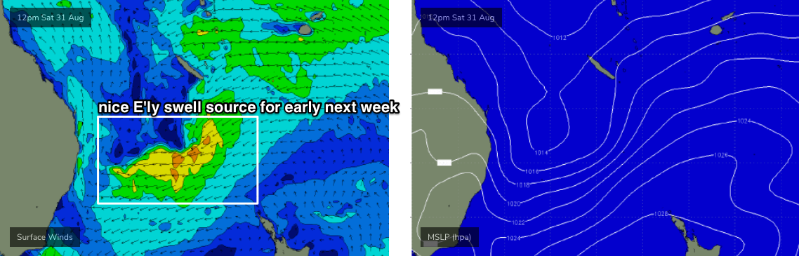
This will rebuild E’ly surf to around 4-5ft across exposed coasts very late Sunday or (more likely) early Monday. The models aren’t really resolving this event right now, so take the swell graph data with a grain of salt.
Smaller surf is expected across the regional points, and we’ll see wave heights gradually taper off into Tuesday and Wednesday as the low tracks further to the east. Indeed, smaller surf will settle in during Thursday, Friday and Saturday as the low tracks north-east from New Zealand and becomes a more distant source for our region.
The good news for the start of next week is that the local trough will have dissipated by this time, leading to light variable winds just about everywhere. So conditions should be great.
Elsewhere, and a series of strong though poorly aligned cut-off lows and fronts will track below the continent over the weekend and through early next week, generating flukey back-to-back southerly swells that’ll probably only favour reliable south swell magnets south of Byron.
This pattern is expected to align more favourably within our south swell window from Wednesday onwards, suggesting an extended period of moderate south swells into next weekend and the start of the following week.
More on this in Friday’s update.
Comments
Finally a mid week swell!
Small but distinct lines of south swell across the Coffs Coast, though it looks like the southerly might just be edging into this region now though.

Actually, here's a slightly bigger set. Bigger than 2ft but less than 3ft.
Southerly has ripped it to shreds now...
Looks almost flat across most of the Gold Coast, but there's the odd small sneaky wave pushing around the corner at Snapper.


Once again New Zealand gets in the way of what would be a helluva party.
is this a record year for swells being blocked by our cuzzy bros?
We are still having a way better winter season than NZ, trust me