Small for the next few days, then a pulse out of the east

South-east Queensland and Northern NSW Surf Forecast by Ben Matson (issued Wednesday 22nd May)
Best Days: Thurs/Fri/Sat: small peaky E'ly swell in SE Qld and Far Northern NSW. Smaller south from Ballina (though Thurs AM should see easing S'ly swell in Northern NSW). Sun/Mon: decent E'ly swell with great conditions.
Recap: SE Qld has seen small peaky E’ly swells for the last few days between 2-3ft, whilst Northern NSW picked up a series of long period S’ly swells, that reached 3-5ft at some south swell magnets south of Byron (smaller elsewhere). Winds have been generally light so conditions have been clean.


Wednesday afternoon peelers at Snapper - check old mate in the first image on the inside, running over the rocks!
This week (May 23 -24)
Today’s Forecaster Notes are brought to you by Rip Curl
The Southern Ocean storm track is aimed well and truly away from our swell window, so we’re not expecting much, if any new energy from this quadrant for the rest of the week. The current south swell will ease gradually both days, so make the most of early Thursday morning (south of Byron) as it’ll deliver the most size.
Across SE Qld, we’ll continue to see average, peaky though totally workable trade swells both days. Surf size should continue to fluctuate somewhere in the 2ft to almost 2-3ft range both days - if anything, with a minor plateau towards the upper end of this size range later Thursday and early Friday - but we’ll see smaller surf from this source as you track south from about Ballina or thereabouts.
As for local conditions, it’ll remain clean across the Mid North Coast both days with light variable winds.
North from about Yamba through into SE Qld, we’ll be at risk of moderate SE winds developing throughout the day but much of the morning should offer variable conditions and clean wave faces. Even the afternoons should remain quite workable, even if the wind perks up.
This weekend (May 25 - 26)
Light variable winds are expected across all coasts this weekend, tending W/NW on Sunday if anything. So, conditions are looking great.
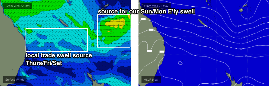
Unfortunately, Saturday will deliver tiny residual surf across much of Northern NSW from Seal Rocks up to about Yamba. However, north from Ballina through SE Qld, we’ll see small fluctuating trade swell in and around the 2ft+ mark at most open beaches.
Sunday looks much better. In addition to a slight W/NW gradient flow (associated with a strong frontal progression across Southern NSW), we’ll see a bigger E’ly swell push through generated by an easterly dip developing out near Fiji at the moment (see chart below). It’s not an amazing system, but should kick up most exposed beaches to 3ft, maybe 3-4ft by the afternoon - though there’ll be very long breaks between the bigger waves and it’ll be smaller running along the points (the relatively low swell periods won’t help much here either).
Confidence on the timing of the swell increase is not high, and it may not be in the water at first light - but we should see a definitive upwards trend by mid-morning, and the afternoon’s shaping up very nicely at this stage.
Let’s take a closer pass on Friday.
Next week (May 27 onwards)
Sunday’s E’ly swell will hold into Monday but then gradually ease in size from the afternoon onwards. With light winds under a weak pressure gradient, conditions will be excellent for the open beaches.
The E’ly dip responsible for the swell will linger in a broad troughy configuration south of Fiji into early next week, which means we’ll see slightly smaller and less consistent but still very useful E’ly swell through until about Thursday or maybe Friday, offering 2-3ft sets at most exposed beaches (smaller across the points).
The strong front crossing Southern NSW on Sunday looks like it'll be too north in latitude to offer favourable swell prospects for our region, though some south swell magnets (mainly in the Far North) may pick up late 2-3ft sets late Monday, holding into early Tuesday. It’s a brief, low percentage event though, so focus on the E’ly swell for your surf planning.
A much more significant low presure system will develop south-west of Tasmania around the same time, but current indications are that it’ll reach peak intensify on the wrong (western) side of the apple isle. If the models shunt this system ten degrees to the east, we’d be looking at a 15ft+ south swell across some parts of the East Coast, but current indications are for the low to weaken as it enters our swell window, resulting in 3-4ft surf from late Wednesday or Thursday morning, building to 5-6ft by Thursday afternoon and Friday. And it’ll be cold and windy from the SW too.
It’s still early days though, so check back Friday for the latest outlook. This is a dynamic winter system and it's going to generate very large surf for somewhere early-mid next week.
Comments
Looking forward to some days with winds remaining firmly offshore. Hope those swells come through.
My favorite recipe sunny, offshore, a spicy board and a bit of swell.
Another unfeasably fun session on Pinky the pool noodle.
No one around, crystal clear waste high dribble in boardies . No leggie. Sprinting after my board across the shallow sandbank and relishing the feeling of being alive and healthy. All cylinders firing.
Then out in the Sea Wok . Fishing in 50 metres without a breath of wind.
Tuna on the surface with flatties nailing livies on the bottom.
Perfect, perfect day.
Off the piss , the sugar and everything processed. Feeling strong . Fish , fruit and veggies.
If I ever see another tube I’ll be fit enough to surf it for hours. Probably won’t even recognise one , it’s been that long , but I’ll be fit enough to get rolled repeatedly.