Easing E'ly swell with a fresh round of S'ly swell
South-east Queensland and Northern NSW Surf Forecast by Craig Brokensha (issued Wednesday 24th April)
Best Days: Thursday morning, Friday morning, Sunday, Monday, Tuesday and Wednesday mornings NNSW
Recap
A slight drop in size through yesterday out of the E and similar today though with persistent onshore winds across the Sunny Coast and Ballina, lighter and more variable offshore around the Goldy and from Yamba south.
Today’s Forecaster Notes are brought to you by Rip Curl
This week and next week (Apr 25 – May 3)
These notes will be brief-ish as Ben’s away on holidays.
We'll see the current E'ly trade-swell continuing to slowly lose size and energy into the end of the week as a result of the trade-flow linked to it weakening this week in the Coral Sea. In saying this though a more distant fetch of persistent E'ly trades will likely provide background levels of swell to an inconsistent 2ft+ until mid-late next week.
Tomorrow should still see surf to 3ft+ across the QLD coast, back to a smaller 2-3ft on Friday and 2ft+ Saturday.
Expect a touch less size further south from Ballina/Yamba.
All locations besides possibly the Sunny Coast should see light morning W/SW winds, giving into E/NE sea breezes.
Friday morning will be best towards northern ends of beaches with a W/NW tending N/NW breeze ahead of N/NE sea breezes.
Our attention then shifts to the south from the weekend as a series of vigorous cold fronts push in across Tasmania and through the southern Tasman Sea.
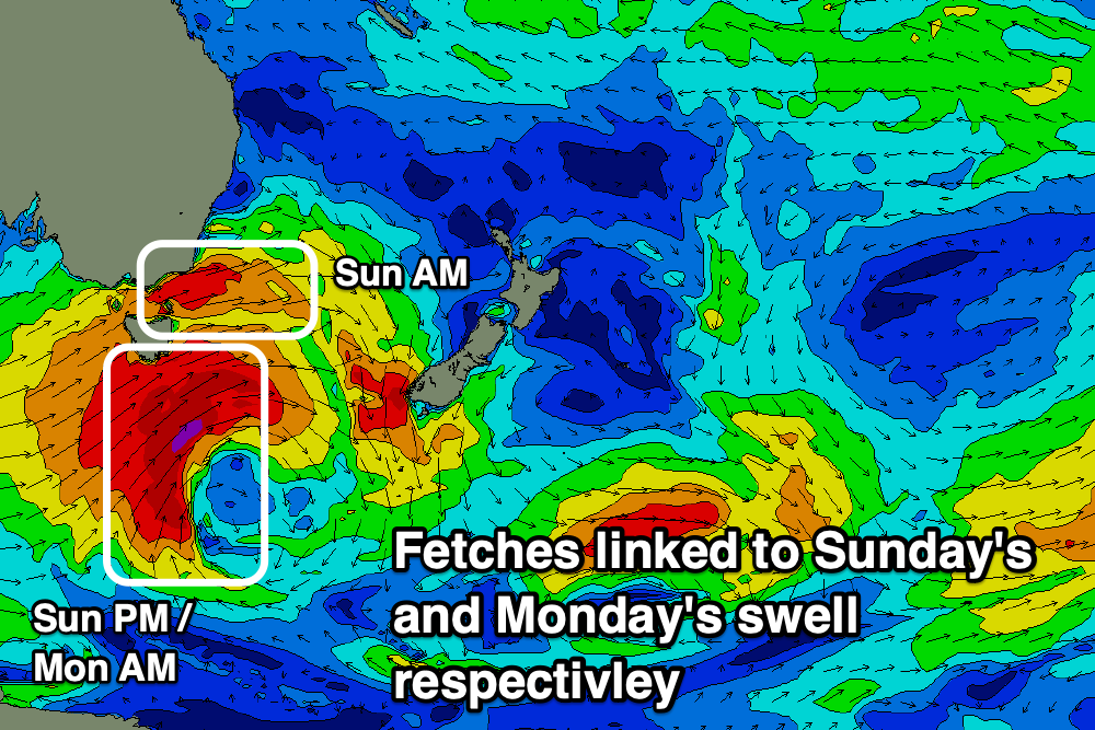
The weekend's first pulses will be produced by the same severe low linked to large surf to finish off the Rip Curl Pro though consistent of two different sources. One will be swell spreading radially up from W/SW gales exiting eastern Bass Strait Friday afternoon and evening, tending more SW while moving up the coast into the evening and Saturday, bringing a S/SW change early morning.
While south of Tassie a much more significant fetch of SW gale to severe-gale winds will generate a better S'ly groundswell pulse for later Sunday and Monday morning.

Each pulse is tricky to discern but it looks like on Saturday we'll see a mix of building S'ly windswell with longer-period swell into the afternoon but with those S/SW-SW tending S/SE winds. Not favourable for south facing beaches. We're only due to see average 3ft sets into the afternoon.
Sunday should be much better with light morning W'ly winds and 4-5ft of acute mid-period S'ly swell, likely easing temporarily into the afternoon ahead of the better groundswell signal overnight and Monday morning.
The groundswell should provide better 4-6ft sets across those south facing beaches on the North Coast, likely a bit bigger on the Mid North Coast while the Gold Coast won't pick up much size at all with the background E'ly swell being most evident across most beaches besides south swell magnets.
Also in the mix Monday will be an additional S'ly groundswell from another front producing a broad fetch of W/SW gales through the southern Tasman Sea Saturday evening and Sunday.
Winds on Monday will be good again and generally variable tending locally offshore and SE into the afternoon, with similar breezes Tuesday as the S'ly groundswell energy eases.
Longer term it looks like we'll see a strong high moving into the Tasman Sea and the slowly over New Zealand, setting up a broad and strong fetch of E'ly trades mid-late next week. This would see fresh levels of E'ly trade-swell building from next weekend and more so into the week starting May 6, but more on this Friday.

