Persistent E'ly swells on hand, light winds from Saturday

South-east Queensland and Northern NSW Surf Forecast by Ben Matson (issued Wednesday 3rd April)
Best Days: Plenty of E'ly swell for the entire period, light winds from Saturday onwards (pockets of good winds Thurs/Fri mornings).
Recap: There’s been a healthy mix of southerly and easterly swells over the last few days. The southerly swell delivered 3-5ft sets at south swell magnets south of Byron yesterday and today, but the easterly swell - sourced from a couple of different fetches - has built slowly, reaching a peak today in the 3-4ft range across most coasts. Winds have been up from the SE but we’ve seen isolated periods of lighter S/SW winds through the mornings.
This week (April 4 - 5)
Today’s Forecaster Notes are brought to you by Rip Curl
Southerly swells are easing across the region and will disappear considerably for the rest of the forecast period.
We may see a small spread of southerly swell push up the Mid North Coast coast on Friday, generated by a strong low pressure system tracking under Tasmania right now, but it’s poorly aligned and therefore I don’t think we’ll see much more than a couple of lazy feet at south swell magnets south of Byron (through into Saturday).
As such, our eastern swell window will remain the focus for the short, medium and long term outlook, and the forecast is generally very positive - plenty of swell, with just occasional bouts of dicey winds.
There’s a couple of sources on hand for the short term: our distant E’ly source from the weekend, plus a ridge across the northern Tasman Sea, offering a little more south in the spectra (the fetch orientation is SE, but the energy spread back to the coast will be E/SE).
We’re looking at a continuation of 3-4ft surf across most open beaches into Thursday, with smaller waves running down the various regional points, with actual size dependent on exposure (much smaller at the sheltered inner points, obviously). Wave heights may ease a little on Friday but this is more likely to be across coasts south from about Coffs, and probably won’t be that noticeable anyway.
Local winds will remain similar to today on Thursday, mainly SE in direction - moderate to fresh north from Ballina, moderate to the south - and easing a little into Friday. The early mornings should again offer brief, isolated windows of SW winds, of which Friday morning should see a broader coverage and longer duration than Thursday.
All in all, more of the same.
This weekend (April 6 - 7)
We’ve got plenty of fun waves in store this weekend, and winds should be light and variable with sea breezes both days.
By Friday, the synoptic charts are expected to consist of a large high pressure system south of the Tasman Sea, and a series of poorly consolidated low pressure troughs stretching across the Tasman Sea and into the South Pacific and Coral Sea. They’ll each direct some form of easterly wind our way; it’d be better if they were all merged as one single system, but instead we’ll see a number of fetches develop and fade, creating a jumbled mix - in a nice way, mind - of small mid-range E’ly swells for the East Coast.
This should maintain peaky 3ft+ E/SE swells across exposed coasts for both Saturday and Sunday, a little smaller south from Yamba (say, 2-3ft). Again, expect smaller waves along the points, especially on the Gold/Sunshine Coasts. And there’ll be a little less oomph in the swell too, thanks to the low periods.
On Sunday we’ll see the arrival of a long range E’ly groundswell generated by a sub tropical low well SE of Samoa over the last few days. Core winds around this low have been recorded in the 50kt range, and there’s also a healthy supporting fetch to its south and east, though the enormous travel distance will shave off quite a bit of size once the swell makes landfall.
I’m still expecting occasional 3-5ft sets at a handful of reliable, exposed beaches - mainly across Northern NSW, and perhaps the exposed northern ends of the Gold and Sunshine Coast at a pinch - but it’ll be smaller running down the points. And, with lengthy breaks of twenty minutes of more between waves, most of the weekend’s surfing will probably be done on the smaller, aforementioned mid-range E/SE swells from sources in the Tasman Sea.
Lastly, the models are showing a small but strong E/SE fetch exiting Cook Strait (between NZ's North and South Island) late Friday that could generate an additional E/SE swell for mid-late Sunday afternoon, though it's unlikely to be any bigger than the E’ly groundswell mentioned above and will probably favour Northern NSW rather than SE Qld. With three or four swell trains in the water, it's plausible some beaches could see bigger peaky A-frames as they mix in together.
Next week (April 8 onwards)
Variable winds are expected in SE Qld on Monday and Tuesday under a local troughy pattern, though we’ll see freshening northerlies across the Mid North Coast, ahead of a fresh southerly change about Wednesday that’ll persist into Thursday, then ease around Friday.
Small, long period S’ly groundswells will glance the coast for much of the week, generated by poorly aligned Southern Ocean low pressure systems. At this stage we could see a new swell front pass across Northern NSW almost every day of the working week, but without any major size it’s not worth getting too excited about. Wednesday’s southerly change may however kick up some bigger S’ly windswell for exposed south facing beaches.
Despite this, we’ve got a great week of surf ahead. A series of easterly dips in the Tasman Sea will move westwards towards the East Coast generating mid-range swell that will provide an extended period of quality waves for most coasts.
Wave heights should average 3ft at most open beaches in Northern NSW from Monday thru’ Friday (smaller at protected spots, and slightly smaller in SE Qld), though early Monday could see larger waves near 4ft, being leftovers from both the E’ly and E/SE swells mentioned for late Sunday (however they'll be inconsistent and easing in size).
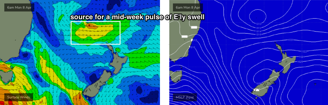
Additionally, we’re looking at a bigger embedded pulse later Tuesday and through Wednesday, from the strongest of the E'ly dips (see chart below) that may evolve into a closed low. Surf size could peak up around the 4-5ft mark at exposed beaches at the height of the event (smaller along the points), though we'll need to monitor updated model runs for changes.
All in all, it's shaping up to be another fun week of easterly swell, with plenty of good waves on offer.
More on this in Friday’s notes.
Comments
Oooooohhhhh yeah dying for some quality mid sized easterly swell! Hope wind plays nice
More o' the same.

Big lump of sand moving towards Snapper
Super fun surf this morn. Waves were solid and running beautifully down the point. Snuck a quick bit of cover on my first wave. Very happy.
Been unreal waves each morning in my hood this week, this morning had the most strength though. Scored a couple of thorough beatings in between some really nice waves.
Was bigger and more consistent yesterday arvo/eve than all of today and only 50 odd ks south as the crow flies..
Interesting. Was different here.. for my eyes, this morning was the biggest, strongest part of the easterly swell cycle thus far.
Still plenty of fun, and clear, warm(almost prepared to say hot) water and also a bit cleaner throughout the afternoon than yesterday.
I surfed this morning and tonight and would be hard pressed to see any difference in size.
Whoa. No change to short term forecast, but the easterly swell sources for next week have largely evaporated in the last few model runs and we've got pretty small surf expected from Tues onwards now.
Quik Pro will want to finish ASAP.
Same again!

