Mix of easterly swells to persist for some time

South-east Queensland and Northern NSW Surf Forecast by Ben Matson (issued Monday 1st April)
Best Days: Most days should have fun waves, though SE winds will confine the best surf to protected outer points.
Recap: It was a bit of an ordinary weekend, with small E’ly swells for the entire period, and freshening N’ly tending N/NW winds Saturday ahead of developing S’ly winds Sunday and a combo of south swells that’ve held into today. However, some locations saw the best waves in a little while this morning (see this video from D'Bah!), with light winds and long period S’ly swells providing 3ft+ surf to SE Qld’s south swells magnets (before the breeze kicked in) whilst Northern NSW’s exposed spots saw bigger surf in the 4-5ft+ range. Protected spots have been really small though, due to the acute swell direction.


Lots of energy at D'Bah this morning
This week (April 2 - 5)
Today’s Forecaster Notes are brought to you by Rip Curl
So, we’ve actually got a couple of additional southerly swells still yet to arrive. Today delivered 4-5ft surf across Southern NSW, and this energy will filter into Northern NSW overnight, providing a similar size range on Tuesday, perhaps a smidge smaller.
At the same time, a long period S’ly swell will gradually overtake the initial mid-range energy, though it’s not expected into the Mid North Coast until mid-late morning, and Far Northern NSW until mid-late afternoon. So, expect periods of size variability across the coast (read: don’t write it off early).
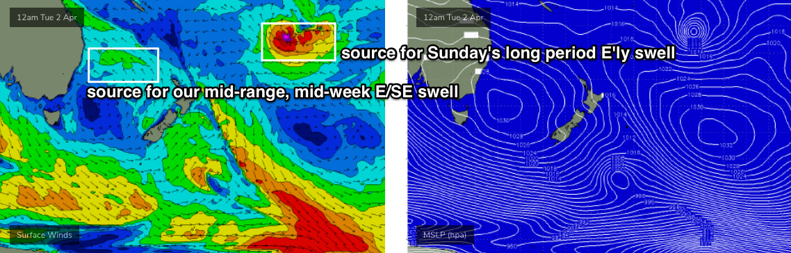
This new long period swell was generated by a deep polar low that formed off the ice shelf well south of Tasmania over the weekend. Satellite data picked up a 50kt fetch around its core, aimed within an acute but definite part of our remote south swell window.
The models have pegged this at 0.6m at 15.7 seconds for around 6pm tomorrow (Coffs Harbour region), but I am concerned by the large travel distance - it’ll result in some seriously inconsistent sets at times. However, Tuesday and possibly early Wednesday (on the backside of both pulses) could deliver occasional 3-5ft sets at south swell magnets south of Byron.
Anyway, for most regions, this won’t be the dominant swell train in the water. We’ve already got a small underlying E’ly swell, generated by broad though modest trades north of New Zealand late last week, and this is expected to increase slowly over the coming days, towards a mid-week plateau in size.
Additionally, a broadening ridge through the northern Tasman Sea will generate a long-lived supply of mid-range E/SE swell energy that’ll fill in the gaps from the inconsistent S’ly and E’ly swells.
Most open beaches should build through Tuesday towards a peak on Wednesday and Thursday around 3-4ft, with smaller waves running down the regional points. A very small easing trend may take place on Friday.
This ridge will anchor in a sustained run of SE winds across the coast, that’ll maintain moderate to fresh strength most days. However, its position against the coast will be weak enough to allow for periods of morning S’ly, possibly even SW flow at some (but not all) locations. The southern Gold Coast is usually a good contender for these morning cross-offshores.
This weekend (April 6 - 7)
More of the same is expected this weekend, with a little less local wind which will bring about an increase chance of sea breezes from the NE: more likely Sunday than Saturday, and more likely in the south than in the north.
A small E’ly dip developing in the north-eastern Tasman Sea on Thursday will move westwards through swell window on Friday. No major strength is expected within the fetch but the westerly push is a good thing, and should rebound wave heights a little into Saturday, with 3-4ft sets at most open beaches, slightly smaller across the regional outer points (much smaller at protected points).
During the day, the leading edge of a distant long period E’ly swell will make landfall, generated by an intense sub-tropical low developing well SE of Samoa at the moment (see chart below).
It’s an incredible looking system, except it’s unfortunately positioned an enormous distance form the coast and this will significantly cap surf size. However we should see peak swell periods draw out to 16-17 seconds, and this should create occasional 3-5ft sets at exposed beaches (against, smaller down the points), though there could be twenty minutes or more between ‘em.
However, most of your surfing will be done on the smaller mid-range E/SE swell, around 3ft at open beaches (smaller on the points).
Conditions do look really nice both days with light winds through the mornings and sea breezes into the afternoons.
Next week (April 8 onwards)
We’ve got a brief period of N’ly winds expected early next week, before another Tasman ridge returns the local airstream around to the SE quadrant.
At this stage, the long term swell trend looks like being more long-lived E’ly swells thanks to stationary Tasman high pressure systems. This will favour another week or so of fun waves across most coasts.
More on that in Wednesday’s update.
Comments
Maybe the wsl hasn't fuct the timing of the quikie pro this year
I wish they had. Makes me happy when that happens.
Well, there's no shortage of E'ly swell at D'Bah this morning.

I reckon there's still a fair bit more south in the mix judging on a few of the south facing beaches this morning
yep.....ASCAT passes showed some vigorous but patchy SE wind fields in the central/northern Tasman .
This is just a classic little SE windswell.
a bread and butter surf we haven't had for 6 months.
Actually, there was a mix of everything in the water. As per the FC Notes, I was expecting 3-5ft S'ly swell y'day and today (Northern NSW) and seeing Southern NSW managed that size yesterday I'm not surprised if there was still S'ly groundswell lines on offer this morning.
But from my vantage point in the water on the Tweed this morning, there was a lot more east in the swell today than yesterday or Monday. Super fun, punchy 4ft sets with long walls.
I am going to assess these long walls myself.