Someone's about to switch on the easterly swell machine

South-east Queensland and Northern NSW Surf Forecast by Ben Matson (issued Monday 28th January)
Best Days: Looks like the never-ending easterly swell machine is about to get a reboot from the middle of the week onwards. Friday looks to be the pick of the forecast period with the best conditions. Plenty of exciting options in the long term outlook too.
Recap: There’s been hardly any swell across most coasts for the last few days, just a trickle of E/NE swell at exposed beaches that increased incrementally throughout SE Qld on Sunday and again today. Northerly winds have generally added further woes to the lack of surf, though they did finally ease back this morning. A long period S/SE groundswell pushed across Southern NSW on Sunday, and some beaches across the Mid North Coast reported anywhere up to 3-4ft late in the day, however most locations dipped out quite a bit, if not completely. This S/SE swell has again provided a smattering of infrequent waves to a handful of swell magnets today.
This week (Jan 29 - Feb 2)
Today’s Forecaster Notes are brought to you by Rip Curl
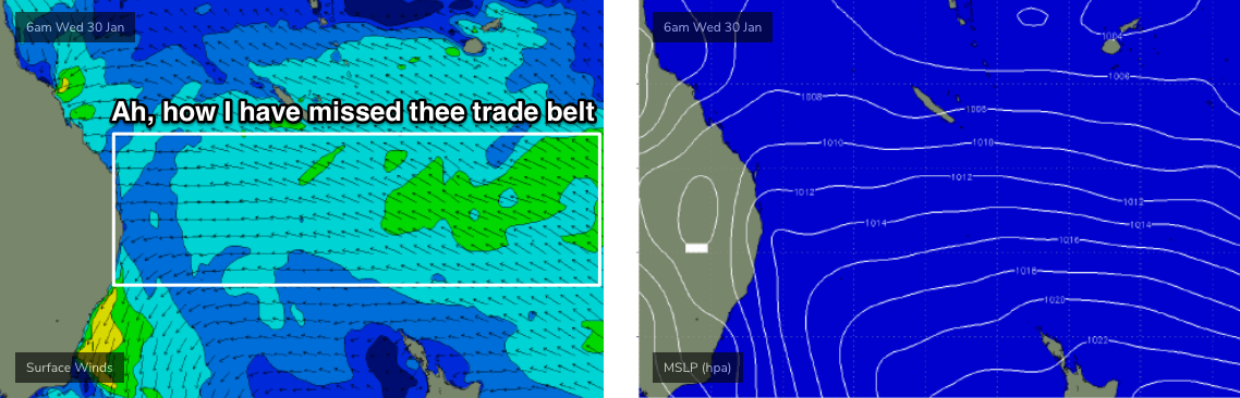
First off: the winds. A stationary Tasman high will maintain moderate to almost fresh N/NE winds about the Mid North Coast this week up until Thursday, but we’ll see less strength north from Coffs, under a light to moderate E/NE flow.
Therefore, there’s a chance for periods of reasonable lumpy/variable conditions at times across the Far North Coast and SE Qld region.
As for surf, the current S/SE swell (patchy as it is) will fade through Tuesday - south swell magnets south of Byron still have some small potential for early Tuesday (as Southern NSW is still around 2-3ft this arvo) but based on the last few days of sporadic surf at best, I wouldn’t get too excited.
Fortunately, the northern flank of the Tasman high will broaden and strengthen over the coming days, slowly building E’ly swells from a low point Tuesday morning (2ft open beaches) up to 3-4ft+ by Thursday, possibly holding in and around this size range into Friday. The upper end of this size range will be north from Byron to the Sunshine Coast (at exposed beaches, smaller down the points), with slightly smaller surf to the south of Ballina.
Friday looks like the pick of the week.
An advancing southerly change across Southern NSW late Thursday will stall across the Mid North Coast on Friday, pushing a trough of low pressure across Northern NSW and SE Qld and resulting in light variable winds at most coasts.
In addition to the E’ly swell, Northern NSW (mainly Mid North Coast) will see a building S/SE tending SE swell from a fetch trailing the southerly change. This won’t be much bigger than the pre-existing E’ly swell but the combined nature of both swell trains could result in some solid 3-4ft+ bombs at a few locations - though most likely south from about Coffs (this S/SE swell will be smaller as you track north, and won’t really show in SE Qld).
Otherwise, just for the record, an intense Southern Ocean low will pass just south of Tasmania on Monday, though it looks poorly aligned within our swell window. The models have long period S’ly groundswell glancing our coast on Wednesday with peak swell periods in the 17-18 second range, but I don’t think there’ll be much size at most beaches - a small handful of reliable south swell magnets may pick up stray sets if we're super lucky.
Additionally, Friday’s notes mentioned a possible sub-tropical low developing NE of New Zealand this week. Unfortunately, it has been erased by the computer models over the weekend, so we can now effectively write it off completely as a swell source.
This weekend (Feb 3 - 4)
The weekend looks potentially very fun at this stage as we finally see a return to typical summer winds and swells.
With the stalled southerly change lying across the Mid North Coast into Saturday, a building ridge of high pressure to the south will broaden an easterly flow through the central Tasman Sea. This will be best aimed toward Southern NSW but we’ll also see a spread to the north, mainly the Mid North Coast where 3-4ft sets are possible in the south, becoming smaller as you head north from about Port Macquarie or Coffs Harbour.
However, there won’t be any shortage of trade swell in SE Qld and Far Northern NSW this weekend, with a strengthening ridge through the Coral Sea expected to generate plenty of E’ly swell around 3-4ft+. Winds will pick up from the E/SE thanks to to the influence of the ridge, and it’ll create problems at most beaches but outer SE Qld and semi-protected Northern NSW points will offer plenty of workable options both days.
Next week (Feb 5 onwards)
I’m pleased to announce that our long term focus will remain entrenched in the tropics for the foreseeable future.
The monsoon trough is redeveloping across the top end, and expected to spin up a couple of tropical lows - and possible tropical cyclones - through the Coral Sea and South Pacific from about Sunday or Monday onwards for the following week or two.
Or course, it’s still a very long time away, and the presence of a cyclone in this region does not necessarily guarantee a swell event of any kind for any coast. However, these patterns are slow moving so it’s shaping up to be an extended period of synoptic watching across the Coral and South Pacific Seas for signs of favourable swell generating systems.
As a bare minimum, we’ll see persistent trade swells holding somewhere around 3-4ft mark for much of next week (again, open beaches, with smaller surf down the points).
Additionally, as of the latest model runs, there's a suggestion we'll see a significant tropical cyclone track southwards along the eastern side of Fiji (and eventually out of the associated swell shadow) around the middle of next week, stalling north of New Zealand - which paints an exciting picture for a large E’ly groundswell in our region later next week and into the weekend.
But it’s still early days, and very likely that we’ll see significant changes to the model guidance with each successive update.
See you Wednesday!
Comments
Yeehah!!
copy that.
Nice! Super excited to get amongst it. Man the water temp around the tweed area was cold today, it's crazy how quickly the cold water is pulled in from that stange phenomenon
Cheers Ben!
Define “cold”
Totally. After a couple weeks around 26 degrees, we’ve needed a 1mm vest to cope with the drop to about 22-23 degrees.
If this persists any longer I may have to consider dusting off the springy.
Ahhhhh. I think you meant the term “Warm”
warm
/wɔːm/Submit
adjective
1.
of or at a fairly or comfortably high temperature.
Inshore temps never got anywhere near 26. Probably 23-24 max, if that.
Water temp yesterday was probably 19-20 where I was.
It's the sudden drop in temp that feels cold, not the actual temp itself.
Lets see what happens next, some of the synoptic progs are very drool worthy, but I ain't jinxing it.
edit: still a lot of insanely warm water rushing down in the EAC, so it should warm again v. quickly once the northerly abates. Sometime this century hopefully.
Back in a full steamer again...
Yep cold as over the weekend, I'm thinking 18 or so on the MNC. Had a 2mm short-arm springy and after 1.5-2 hours fairly cold.
Doesn't help that you're as skinny as a rake.
Coupla kids and a mortgage will add a lovely pouch around the stomach that'll assist with these upwelling events.
Haha...as expensive as they are getting, I still think a wetsuit is cheaper :)
Haha easy on ;p
Bizzare patches of really cool and bathwater warm on the tweed this morning.
(i'm not sure we have a licence to use the word cold up here!)
Small with no walls or sections equates to stalls and Kook squats. Lovely temps and clean water here in the northern sector though.
Hmmmmm, might be time for a FIFO. Sorry Freeride & friends. I’ll be as inconspicuous as I can be
Just to put things in perspective, Wellington water temp dropped to 13-14C due to persistent northerly gales. Back in my 4/3 for a couple of days!
Was at the public pool a week ago, pool attendant took the temp ...30.5.. was like a warm bath...obviously!
human soup.
Incubator
yeeeeewwwww. Trade swells. Big board is ready. Took out old plugs and put fcsII's in. ready to roll. Did I say yeeeeewwwww?
big board?
Froth spilling over already
hey Ben. How come there's a poor correlation with the size predictions in the Forecaster Notes vs the 16 day bar graphs? For example, this Friday, the Notes talk about 3-4' and the bar graph shows 2'?
hey mate, to be fair - it actually says 2-3ft for most of Friday but eases to 2ft at 6pm (for the Gold Coast at least).

Model guidance is exactly that: 'guidance', created by a computer model that has no form of quality control.
My written notes are based on my own forecasting techniques - there's not much point in simply verbalising the computer generated forecast graphs. As such, on Monday when I wrote those notes, I deduced that we'd see a little more size than the models were estimating.
I'll have an update this afternoon.
cheers Ben. Your answer makes complete sense. Thx for going to the effort
Not much size around byron today, grovelling for some 2ft peaks on the dropping tide an hour ago, hopefully size fills in by tomorrow.
Winds could be a bit iffy for this east swell.
Great image on Weatherzone showing the position of the high pressure anomaly which would explain the "nuclear nor easters" on the Mid North Coast. It was blowing 15knot at 7am this morning FFS.
http://www.weatherzone.com.au/news/hot-and-dry-start-to-2019-in-nsw-act/...
The fundamental problem of weak and mobile high pressure ie. spring-like conditions is still being exacerbated/caused by the Tasman sea heat wave.
High SST anoms there are filling up high pressure systems because warm air rises .....making for continuing weak pressure gradients and higher likelihoods of northerly wind episodes.
This next high is already looking weaker than it did on prognosis charts from a couple of days ago.
the one following that looks stronger, but we shall see.
Not sure what Ben said in the notes but based on the latest ASCAT pass and progged wind speeds I highly doubt we'll see 3-4ft Friday.
More like a slow, slow build to something around 2, maybe 2-3ft.
I'll weigh in with some observations garnered from having lived 24years on the sunshine coast, and now on MNC NSW.
I've noticed a trend over the last 5 years or so of the high pressure systems setting up as "belts", rather than nice big ovals moving out into the tasman and centering over the NZ region.
Now a high pressure belt is all well and good, particularly as it can get a number of dips in it with low pressure systems out in the SPAC. But it can also result in extended periods of funky winds to go with it. Think 24hr E on the sunny coast, and The dreaded Noreasters that have been plagueing the MNC for the past however many weeks its been.
WTF has happened to those big 1032+ big high pressure systems that use to slip out into the tasman? They delivered more of a swell cycle. Where you would get a fast rising though typically pretty short interval SE swell as the leading edge of the high set up a little fetch in the tasman. Then the swell would back off before reforming as an E swell off the top of the high (garden variety trade swell), where you would get a couple of days on the points. Then you would get a couple of clean mornings on the beachies on the back end of the swell before the next big high pushed across.
What happened to these systems, I miss those days!
Anyone noticed how very few true SE swells this past couple years. Always more east or south of that?