Continuing easterly swells for some time; plus a decent south swell in the mix

South-east Queensland and Northern NSW Surf Forecast by Ben Matson (issued Monday 7th January)
Best Days: Entire period: sustained run of E'ly swells, pulsing late Thurs/Fri/Sat, and then again early-mid next week. Long period S'ly groundswell across Northern NSW on Wed too.
Recap: Weekend wave heights came close to, but ultimately near the bottom end of forecast expectations, 4-5ft at exposed Sunny Coast beaches (no + sets), 4ft on the Gold and Tweed Coasts (against the forecast of 4-5ft ), grading smaller south from Byron to 3ft+ across the Mid North Coast. In most areas, winds were either light and variable, or light to moderate onshore, and with no discernible wind trend (aside for the Mid North Coast, which saw freshening N’lies Saturday and early Sunday ahead of a S’ly change), there were pockets of very fun waves across many stretches of coast. Wave heights eased a little today but it’s still managing 3-4ft across SE Qld, grading to about 2-3ft across the Mid North Coast, which is also seeing a small concurrent SE swell from a stalled trough related to Sunday’s change. Todays winds have been similar to the weekend, though the onshore has been fractionally stronger, however it’s worth pointing out that up until 4pm this afternoon, average wind speeds across the Gold and Sunshine Coasts maxed out at 13kts - so it’s not terribly strong.
This week (Jan 8 - 11)
Today’s Forecaster Notes are brought to you by Rip Curl
Feels like we’re about to see Groundhog Day for a little while longer yet, with this same pattern of easterly swells and light variable tending light to moderate onshore winds forecast to persist across SE Qld and Far Northern NSW.
After a couple of brief days of respite, the Mid North Coast will resume freshening N/NE tending N’ly winds Tuesday and Wednesday before it temporarily abates from Thursday onwards.
As for swell, the current trade regime will persist mid-week though at slightly smaller size than what we’ve seen over the last few days. Exposed SE Qld beaches should maintain 3ft+ sets (smaller running down the points) with decreasing wave heights as you head south from Byron Bay.
We’ve actually got an interesting southerly groundswell on the way for next few days too. A deep Southern Ocean low has generated a long period S’ly event that’s just pushing into Tasmanian coasts as we speak, and its leading edge will reach the lower Mid North Coast very late Tuesday, building overnight and into Wednesday across remaining south swell magnets south from Byron Bay.
This swell will exhibit long swell periods (18-19 seconds) that’ll exaggerate wave heights at reliable south swell magnets, somewhere around 3-4ft+. Note: the wave model (as per usual) is not picking up this swell very well, so my estimate is significantly above the guidance.
It's also worth pointing out that these kinds of flukey long range south swells often don't light up every beach (even those facing south), so if you don't see the results you expect at your local swell magnet, check a few other spots to see how they are faring. Wave heights will ease from this source into Thursday.
Elsewhere, and unfortunately we’ve had a downgrade in estimated surf size from TC Mona, out near Fiji - the cyclone hasn’t quite developed as much as was estimated on Friday.
However, we’ll still see a new E’ly swell fill in on Thursday afternoon (above the pre-existing trade swell, and the easing S’ly groundswell), and should reach a peak into Friday with inconsistent sets in the 3-5ft range across exposed beaches, mainly Northern NSW but also across northern ends of the Gold and Sunshine Coasts (a little smaller running down the points).
Light variable winds and sea breeze are expected in all areas to finish the week - including the Mid North Coast - so there’ll be great waves right across the entire coast, and it’s well worth booking in a couple of sessions.
This weekend (Jan 12 - 13)
We’re shaping up to see a fun weekend off waves, with steady E’ly swells from TC Mona gradually easing from an inconsistent 3-5ft to 3-4ft from Saturday morning through Sunday afternoon.
This easterly swell will be in addition to a small pulse of S’ly swell across Northern NSW (on Saturday), originating from a broad but ultimately disjointed series of Southern Ocean lows passing south of Tasmania mid-week. The south swell should provide 2-3ft sets to south swell magnets south of Byron Bay.
Winds look good all weekend across SE Qld and Far Northern NSW under a weak pressure gradient, but only Saturday looks like being beneficial for the Mid North Coast, with Sunday expected to see a renewal of N’ly winds as a high develops in the Tasman Sea.
Next week (Jan 14 onwards)
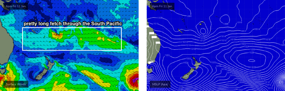
A broad region of troughiness near Fiji all week - hosting the remnants of easing (by this time) ex-TC Mona is modelled to spawn a new tropical depression over the weekend, that looks like being a good source of E’ly groundswell next week. The easterly flow will stretch way back out into the South Pacific (see chart below) that'll ensure we see some form of easterly swell all of next week.
Additionally, a building ridge through the Coral Sea will generate some local secondary trade swell for SE Qld.
Wave heights should increase steadily into the 3-5ft range at exposed coasts by Wednesday (a little smaller prior to this), however once again it appears that we’ll see problematic N/NE winds across the Mid North Coast. Winds will be lighter throughout SE Qld and Far Northern NSW but the latest modelling suggests it may be a touch stronger than what we’ve seen recently.
In any case, there’s no sign of any let up in the easterly swell regime, and there’s always a chance that there’ll be pockets of favourable winds across most coasts, so it’s looking like we’ll all be very active for the next couple of weeks.
Elsewhere, and a strong front passing south of Tasmania on Saturday will also generate a fresh though brief S’ly swell for Northern NSW early next week too, whilst lingering troughiness through the southern Tasman Sea should contribute small SE swells for Northern NSW around the same time.
See you Wednesday!
Comments
This is shaping up to be the best summer season of surfing I've had since I started surfing in 2002. If it continues like this, autumn is going to be cooking. Touch wood.
Unreal mate. Which coast?
Obviously not on the Mid North Coast.......
Opposite here, what's your address?
"Winds look good all weekend across SE Qld..."
Care to put that in knots and direction?
Second half of that sentence was the clue.. "under a weak pressure gradient". Light and variable.
Though ironically, the overnight model update has completely moved this around, building a ridge through SE Qld (and freshening E/SE tending SE winds) whilst resulting in light variable winds on the Mid North Coast (contrary to yesterday's model runs).
Still, it's five days away so there's plenty of time to firm things up.
Thanks mate appreciate it.
How's the complete lack of arvo storms rolling in from the west so far this summer too, just to rub salt in the non-stop onshores wound.
We had some crackers around Xmas, but nothing since. Waiting patiently!
The ocean’s a real sight this morning, enough to strap on the joggers and go for a trot instead!
Hey Ben,
Merry Xmas and a Happy NY to you and your family!!!
Just wanted to know is “troughiness” a real thing?
Cheers
It essentially means a somewhat broad area of low pressure with one or more troughs moving slowly through it, resulting in (with regards to surf conditions) brief, periodic, shallow wind changes from multiple directions.
Troughiness is a term employed by an infamous urophile , known as the Trough Queen , who frequented Sydney’s Mardi Gras after parties to rate the flow of the warm , salty liquid sprayed over his leather clad visage as he lay prone in the Men’s urinal. A higher troughiness equated to a more thorough soaking and a greater experience.
Apparently the troughiness was higher in the days before pills, when a higher percentage of the gay scene drank alcohol. The Trough Queen was reputed to be the alias of an influential Shock Jock in the region , though this has never been definitively corroborated.
https://en.m.wikipedia.org/wiki/Troughman
Does this answer your question ?
Ben will answer for himself, but I think it's in common enough usage to mean what it says.
ie, if there is a pattern of constant troughs it's fair enough to refer to "troughiness".
edit: see above
the resilience of this pattern is now becoming quite extraordinary.
I count 15 straight days of northerly component winds and 29 out of the past 39 days as same.
to the original poster: God help us if this pattern extends into Autumn.
Hearin ya loud and clear Steve!!! It's the middle of January almost and we're still talking about N'ly winds FFS!!!
That run of nor-easters has been the best kitesurfing Xmas season in memory on the east coast, keeps some of us happy Don!!
The combat sailplane/gliders have been loving it too, though not sure the falcons/kestrels are loving those blowins.
That's climate change for you freeride. All the models show that once a weather pattern forms it becomes much more stable than previously. My money is on the first week in February for something better.
Climate change, pffttt.Summer of 95 very similar, more East than Nor east winds but day after day relentless wind and swell, surfed Noosa near on everyday,almost got sick of it, was looking for excuses not to surf that year....
Blue bottles starting to get a bit old.
I think we might be forgetting we almost missed our usual spring. It was
early tradeswell with light winds, barely more than a couple of northerly days in a row. Would have to be the best spring i can remember.
Are we paying the price now?
Well, this is the best summer of waves I've had in ages.
It's all relevant to your specific requirements, and expectations.
Of course, the sand's been terrible for some locations (i.e. Gold Coast points) but it's been very good for other spots. Just depends what you want to surf, and the lengths you'll go to surf it.
Last night was probably the most crowded session I've had all summer with 10-15 guys when I paddled out, which dwindled to just 5-6 within half an hour. I've had many sessions on my own or with one or two other surfers.
Yeah echo that Ben. I don’t mind slightly windy beachies as such haven’t surfed with anymore than 1 other guy for the the past week. Plenty of sand if you know where to find it.
Nothing wrong with hitting crumbling lips, floating over the foam even getting drilled in closeouts can be fun. But no fun when the stingers get me!
Surprised at the lack of stingers in my neck of the woods considering the winds so far this summer.
Over such a long stretch of coastline from Qld to Mid North Coast NSW conditions can obviously vary a lot and the onshore winds in the north of the forecast area can’t have been as problematic there as they have been in the south.
I reckon the images from the Port Macquarie surf report today pretty much sum up the last month. Dirty, cold and bumpy, Can still find waves on the back beaches but tends to concentrate the crew.
https://www.swellnet.com/reports/australia/new-south-wales/port-macquarie
Obviously there have been some regional variations with winners and losers, but taking the whole forecast area into consideration and accounting for the continual downgrading of swell potential from 3 tropical cyclones and more tropical depressions any objective reading of the Xmas/New year period would have to come to the conclusion that it has been a period of consistent mediocrity.
I do agree with your assessment BB.....I think one aspect of summers here that seems to becoming more common is this persistent spring-like northerly flow and the failure of the more typical tradewind flow in the Coral Sea due to very weak high pressure in the normal sub-tropical/temperate high pressure belt.
The tradewind flow producing this swell has by and large been in the South Pacific and with the Tasman/NZ high pressures being weak it's main feature has been a lack of power (compared to more typical CS Tradewind flows) and a consistent northerly component wind.
That failure of Tradewinds and northerly flow seems more and more common in summer now.
No observable arrival of that south swell ben?
Which coast are you mate? Crowdy Head and Coffs Harbour buoy picked it up nicely overnight, and we've had some reports of good south swell showing at a couple of south swell magnets.
http://new.mhl.nsw.gov.au/data/realtime/wave/Buoy-crhdow