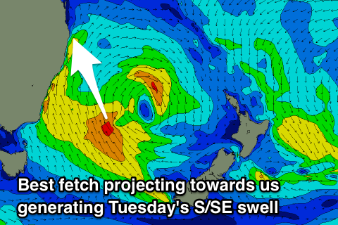
Acute S'ly swell Sunday, larger better S/SE swell Tuesday morning
South-east Queensland and Northern NSW Surf Forecast by Craig Brokensha (issued Friday 11th May)
Best Days: Sunday morning northern ends of beaches, Tuesday morning, Wednesday morning
Recap
A mix of easing E'ly and new S'ly groundswell across the NSW with generally favourable winds all day, fun across the Gold and Sunshine Coasts through the morning before the N'ly kicked in on the former.
This morning we saw clean conditions across all locations with smaller easing surf.
Today’s Forecaster Notes are brought to you by Rip Curl
This weekend (May 12 – 18)
These notes will be brief as Ben’s on holidays.
There's not much on the cards for tomorrow with small background levels of E'ly swell along with gusty W/NW tending W/SW winds.
The structure of the strong Tasman Low sitting off the southern NSW and Tasmania coast has changed a little with the fetch generating Sunday's very acute S'ly swell being mostly aimed away from us and into the Tasman Sea.
Through tomorrow we're expected to see a a fetch of S/SW gales projected up the southern NSW coast and SW gales off the Hunter region more in our swell window.
This doesn't look ideal at all for swell generation, but with strong S/SW winds emanating off the back of the SW fetch and pushing more up the northern NSW coast, a developing S'ly swell is due through Sunday.
 We're looking at less size than expected on Wednesday with south magnets south of Byron due to come in around 4-6ft, much smaller at open beaches with the acute southerly direction. The Goldy will likely be tiny Sunday morning, with the S'ly swell kicking to possibly 2-3ft at south magnets through the afternoon, tiny elsewhere.
Winds will be good through the morning Sunday with a fresh W'ly, swinging S-S/SE into the afternoon.
We've got better swell potential into next week as the Tasman Low pushes east into the Tasman Sea, opening us up to a much better fetch of strong and elongated S/SE-SE winds.
A slight drop in size in S'ly swell is likely Monday morning but a good fetch of strong S/SE winds projecting north towards us through the afternoon, with an embedded fetch of S/SE gales further south on Sunday evening should generate a better S/SE swell for Tuesday morning.
A late pulse in size is likely Monday, but Tuesday morning should reveal 6-8ft sets across northern NSW and good 3-4ft sets on the Gold Coast (bigger bombs at south magnets).
Winds Monday look SW during the morning (W/SW in some regions), swinging S'ly through the day and then SW tending S/SE winds on Tuesday.
A slow drop in size is expected on the backside of the swell as a slowly weakening fetch of S/SE winds continue to be aimed through our swell window until Tuesday morning. The mornings will be the pick with SW offshores, tending S-S/SE through the afternoons.
More on this Monday though, have a great weekend!


Comments
I followed the model runs over the weekend and not this write-up and got completely skunked at the southern end of the NNSW north coast. Models had 3ft/6ft south facing beaches @ 9 secs, which translated into a sluggish (but clean) 2-3ft at a very exposed location
Ah bummer.
Don't know where you went but it was easy 6ft yesterday where I surfed and 4-5 today.