Sustained series of strong south swells coming up

South-east Queensland and Northern NSW Surf Forecast by Ben Matson (issued Monday 4th September)
Best Days: Wed: building S'ly swell in Northern NSW (tiny in SE Qld) Thurs: bigger, stronger S'ly swell (only small in SE Qld). Fri/Sat: large S'ly swell in Northern NSW, small waves in SE Qld. Sun: moderate, easing S'ly swell, offshore winds (only small in SE Qld).
Recap: Strong though easing S’ly swells on Saturday still managed to produce some sizeable options south of Byron early, with 4-6ft sets on offer. Surf size was much smaller across SE Qld though exposed northern ends saw occasional 3-4ft sets early morning. Winds were mainly light across most coasts. Sunday saw steadily easing S/SE swells and freshening N’ly winds, which have persisted about northern regions today, generating 2-3ft of N/NE windswell about the Gold and Tweed Coasts. Winds have been lighter and more NW thru’ W/NW across the Mid North Coast, though the N/NE windswell has been smaller here.

Plenty of N/NE windswell at D'Bah this morning
This week (Sep 5th - 8th)
N’ly winds will remain at strength for the next few hours though gradually ease from later this evening onwards. As such the current N/NE windswell across the Gold/Tweed Coasts will ease into Tuesday. Early morning may see some lingering 1-2ft sets at exposed north facing beaches but otherwise it’ll be tiny elsewhere. Conditions will be clean with light variable winds.
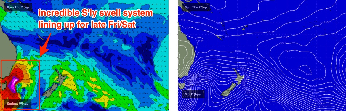
As for new swells throughout the forecast period - we have a very active progression of fronts across the SE corner of the country. Although their initial alignment is out of our swell window, the sheer coverage of strong winds and their slow moving nature will ensure we see some spread back towards the mainland. And then later this weekend and into the weekend we’ll see large waves from the back end of the progression as it moves into as better part of our swell window.
Initially, the first round of new energy will be small, low confidence energy originating from a brief fetch of westerly gales exiting eastern Bass Strait today. In general, this airstream has been more W/NW than W’ly so it’ll generally be aimed towards New Zealand with very little spread towards our coast. But a minor tweak in the fetch alignment is modelled for later today, and this may provide a small brief spread of south swell to glance the coast late Tuesday (Mid North Coast) and early Wednesday (remaining Northern NSW south swell magnets).
Early morning surf conditions will consist of small residual energy from today. I’ll be surprised if south facing beaches south of Byron pick up much more than 1-2ft from this source. Elsewhere it’ll be tiny.
A more sustained W’ly flow exiting eastern Bass Strait on Tuesday will set up a slightly better aligned S’ly swell for Wednesday afternoon, though once again there’ll be a large range in size across the coast, and many beaches will remain tiny. South swell magnets south of Byron could see late sets pushing 3ft+ though it’s hard to have confidence in the arrival time, as this swell won’t be pushing up the coast, as spreading back into it. This means we’ll see much closer arrival time between all locations from Seal Rocks to SE Qld and reduces the early heads up via offshore wave buoys.
Protected locations will however remain tiny as this south swell builds (because of the direction), and I doubt we’ll see much surf north of the border either - maybe some very late 1-2ft sets at exposed northern ends if we’re extremely lucky. Certainly don’t plan anything around this swell if you're north of Coffs Harbour, as it’s not a high confident event. Conditions will be generally clean with light variable winds though.
A powerful secondary front will round the Tasmanian corner early Wednesday, shifting the broadscale flow to the W/SW thru’ SW and this will create a much bigger southerly swell for Thursday, building across Northern NSW throughout the day.
Fortunately, conditions will remain clean again with light variable winds in the north and W/SW winds across the Mid North Coast. South facing beaches south of Byron Bay should build to somewhere between 4ft and maybe 6ft by the end of the day (greater chance of this on the Mid North Coast, owing to its closer proximity to the swell source). But once again, it’ll be much smaller at beaches without any southerly exposure so keep in mind the large size variation across the coast.
SE Qld won’t see much size from this new south swell, I’m expecting tiny conditions across the outer points and maybe some 2-3ft sets at a handful of south swell magnets and exposed northern ends, through the afternoon. Smaller surf is likely in the morning.
While this is going on, a very intense front and low - the most powerful in the sequence - will have traversed the Tasmanian region on Thursday and set up storm force S’ly winds off the South Coast. This is expected to generate a brief but very large S’ly swell that is currently modelled to build through Friday afternoon - but I’m not confident on the timing, and we may not see this swell across the Far North Coast and SE Qld region until Saturday. As such prior to its arrival, expect similar levels of leftover swell as per late Thursday (perhaps down a touch).
Friday afternoon’s new south swell could very well push up into the 6-8ft range at south facing beaches south of Byron, with smaller surf at remaining beaches around 3-5ft.
Across SE Qld - assuming it arrives before 4pm (and that's only a low chance at this stage) we’re looking at 2ft+ surf across the outer points and 3-4ft+ sets across exposed northern ends. However, it’s expected to be a rapidly transitioning system that’s only forecast to last a short time in our swell window, so we really need a few more days of model guidance to firm things up.
In any case, the overall trend is up each and every day until the end of the week. Check back on Wednesday to see how the models are behaving.
This weekend (Sep 9th - 10th)
The large south swell due late Friday is likely to be trailed by a strong secondary front in its wake, which should keep wave heights very strong through Saturday.
Model guidance currently has Saturday as seeing more size than Friday, but I have a feeling we’ll see things switch around over the coming days. Either way, we’re looking at a solid start to the weekend in the south swell department, and favourable W/SW winds too.
Ball park figures are in the 6-8ft range at south facing beaches south of Byron, with smaller surf elsewhere around 3-5ft and smaller surf again across SE Qld, anywhere from 3-4ft at exposed northern ends to 2ft+ across the outer points. Winds are due to swing moderate to fresh SW across the Mid North Coast, associated with the frontal passage, but it’ll remain light and variable in the Far North and SE Qld regions. Size will probably trend down into the afternoon.
This pattern will ease steadily into Sunday, with light winds creating clean conditions just about everywhere.
Next week (Sep 11th onwards)
There’s nothing off any interest in the long term charts at this point in time. Everything is focused around our large south swell due later this week and into the weekend.
Comments
Baby lines of leftover N/NE windswell this morning.
Found a nice bit of hard packed sand that was tons of fun. Seemed like 1ft south swell mixing with 1 ft nth swell. I was at a sth magnet though.
Clean lines of new S'ly groundswell across the Tweed Coast this morning. Only 1-2ft but super smooth with crystal clear water.
Yep definitely the leading edges of new south through here this morn