Easing E'ly trade-swell, S'ly pulses for Northern NSW
South East Queensland and Northern New South Wales Surf Forecast by Guy Dixon (issued Friday 25th March)
Best Days: Each morning, particularly Monday south of the border
Recap:
Good options have been breaking in the 3-4ft range over the past few days as easterly trade energy peaked. Early southwesterly breezes allowed for clean conditions each morning, deteriorating with the seabreeze later.
This weekend (Saturday 26th - Sunday 27th):
Over the past few forecast notes we have been looking at a good looking easterly trade fetch which has been lingering just north of New Zealand earlier in the week. This system has broken down, so we should see a gradual easing trend over the weekend.
Saturday should see sets ease slowly from the 3ft range, furthermore on Sunday easing from around 2-3ft, with the more exposed open beaches picking up the most energy. The size is not likely to be as pronounced across the more protected points.
As this source of swell slowly winds down, we are due to see a series of pulses of southerly groundswell breaking across back beaches and magnets, generally across Northern NSW.
An initial pulse is due to fill in on Saturday morning, with sets breaking in the 3ft range by lunchtime generated by a front and small embedded low which edged into the southern swell window on Wednesday.
After fading from the 2-3ft range on Sunday, a pair of pulses are due to fill in on Monday in fairly quick succession, providing a kick to the 3-5ft range by the afternoon, although inconsistent at times.
The system responsible for the first pulse is currently working on an active sea state deep in the Southern Ocean, with broader, more elongated fetches than the last.
The third and final pulse looks to be generated by a strong front moving to the south of Tasmania this evening, displaying fairly intense southwesterly fetches.
One factor of these southerly swells that is worth considering is the active sea state of the Southern Ocean. Swell generating across this part of the globe is efficient and paid due to the unsettled nature of the ocean. Any systems which work upon this unsettled sea state may quickly generate a strong swell.
Now for the wind outlook, early southwesterly breezes are on the cards for southeast QLD, more west/northwesterly south of the border. Breezes look to tend northerly before swinging northeasterly later.
Sunday looks to see light west/southwesterly breezes over southeast QLD early, more northwesterly along the Northern NSW coast. Conditions should remain clean/workable during the mid-morning session, before a light seabreeze sets in.
Next week (Monday 28th onward):
As we move into the early stages of next week, easterly trade energy should hold in the 2ft+ range, preceding a brief hiatus before the next building trend.
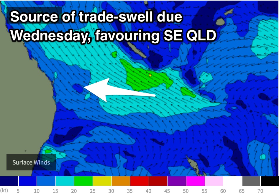
 East/southeasterly trade-swell is expected to be in the water around Wednesday with inconsistent sets in the 2ft+ range generated by an east/southeasterly fetch over the Coral Sea in the days prior. This fetch is most favourable for southeast QLD coasts due to the alignment, grading smaller further south.
Meanwhile, a longer range easterly groundswell from a distant easterly fetch is due to build through Wednesday afternoon now and hold into Thursday morning with very inconistent sets in the 3ft+ range.
Finally, beaches south of the border can make the most of the remnants of southerly swell on Tuesday however, fading from the 3ft+ range.
Winds are looking light for Monday morning across most coasts, southerly across southeast QLD, more offshore for a brief period along the Northern NSW coast.
A similar pattern looks to ensue in the following days, with workable conditions early, preceding an onshore change.
More detail next week.


Comments
Pumping waves every day by the looks. It was pumping this morning in northern New South Wales. Even at 11:30 a.m. the ocean was sheet glass. I could not get over the power of the waves this morning full turbulent duckdives, hold-downs, getting thrown off my board even on smaller 2 to 3 foot waves very odd. A sign of autumn, my favourite time of the year. Thanks for the report I look forward to the next few days
Friday was definitely bigger and stronger than Thursday. By far!!
Pulsing 4ft BH, shame about the wind tho.
Peaky 2ft ESE ? Nah.
Can't remember the code to embed the photos here but we scored close to epic surf this morning, you could definitely feel the new southerly pulse in the water at 6am, same spot yesterday was around the same size but this morning had big hold downs where you are pinned on the bottom with your board on top of you. 4-5ft sets rolled through towards the end, this spot is a magnet though
That's bloody nice . What coast was that
East Coast;)
looks 3ft
Back on deck now. Looks 2ft+ from the east across the Goldy (via the cams) but I scouted some of the local beaches south of the border a little while ago, and they're already picking up 3ft+ sets from the new south swell. Easter crowds in full force though, and the beaches seem gutted and quite bankless. Might check 'em out once I've done the forecast and the crowds head home later in the day. Hopefully we'll see a little more size by then too.
Good holiday Ben!
Yep, super fun. Some good waves, plenty of relaxing.