Tricky weekend ahead; small trade swell early next week then a new S'ly swell mid-week
South East Queensland and Northern New South Wales Surf Forecast by Ben Matson (issued Friday 5th June)
Best Days: Sun: small trade swell in the north, small S/SE swell in the south, generally good winds. Mon thru' Wed: small trade swell in SE Qld. Wed/Thurs: strong S'ly swell in Northern NSW.
Recap: Thursday delivered large 6-8ft surf across exposed parts of the Northern NSW Coast, but due to the swell direction wave heights were signifccantly smaller in SE Qld. Conditions were however clean with light winds for much of the day in most areas. Today, surf size has steadily eased from the S/SE and freshening offshore winds have kept conditions clean.
This weekend (June 6 - 7)
The current S/SE swell will continue to trend downward through the weekend. We’ll see some small reinforcement from a series of smaller, distant S/SE sources, originating from a frontal passage extending from the ice shelf up into southern New Zealand over the last few days. However surf size will be smaller than the last few days, and it’ll be biggest at south facing beaches in Northern NSW (not much of this swell will make it past Cape Byron).
The main factor influencing the weekend is a developing trough off the North Coast, which will mainly affect local winds and conditions north of about Coffs Harbour. Fresh and gusty SW winds are expected to develop overnight and hold into early Saturday morning before swinging fresh S’ly then SE throughout the day.
The onset of these SE winds will occur earlier in the south than in the north however aside from a building local short range S’ly and small mid-range SE swell across Northern NSW (bumpy 3ft+ sets at exposed beaches), I don’t think this system will produce much, if any quality swell for those regions that can cope with these winds (i.e. the semi-exposed points in SE Qld). The automated model forecasts for the Gold and Sunshine Coasts have an afternoon increase but I’m skeptical it’ll eventuate to any great degree; maybe late afternoon if we're lucky (exposed beaches will pick up some new energy but it'll be wind affected).
South of about about Coffs Harbour, local winds are expected to be only moderate to fresh in strength on Saturday and the developing sou’easter will probably weaken through the afternoon, so conditions should be much more manageable here. We should see a building SE swell across this coast too but it’ll probably be about the same size as the pre-existing distant S/SE groundswell (sets in the 3ft range). So tuck into a sheltered southern headland for the best waves.
On Sunday, local winds should improve just about everywhere thanks to a high pressure system moving eastwards across the Tasman Sea. Light variable winds are anticipated for much of Northern NSW, with a residual mix of S/SE groundswell and mid-range SE swell off the trough, with peaky sets in the 2-3ft range.
SE Qld will still see a synoptic SE wind on Sunday but early morning should favour a brief period of SW winds. Surf wise, we’re looking at 2-3ft waves across the semi-exposed points, with bigger sets at exposed northern ends. I’m not expecting any major quality but there should certainly be some rideable options.
Next week (June 8 onwards)
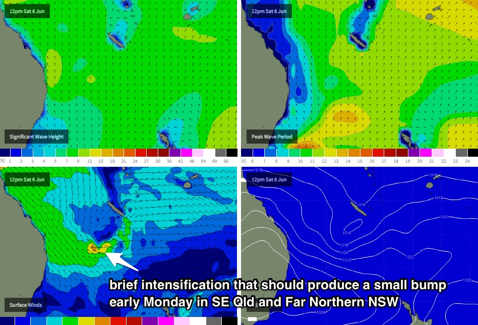
A momentary intensification within the trade flow across the Southern Coral Sea early Sunday morning (see chart below) should renew SE swell across the Far Northern NSW Coast, and the Gold and Sunshine Coasts overnight Sunday and into Monday morning, with 2-3ft+ sets expected across the semi-exposed points (and bigger waves at exposed northern ends). Winds should be light and variable by this time so conditions are expected to be very clean.
This SE swell will taper off in size with increasing southerly latitude south of about Ballina, but light NW winds will maintain clean options across the open beaches on Monday. Our south swell window will go quiet over the weekend so Monday and Tuesday are expected to see only small residual energy - including some small trade swell - across the remaining Northern NSW coast during this time.
The trade swell will probably ease back a little mid-week but we’re still looking at inconsistent 2ft to occasionally 3ft surf across SE Qld thanks to a persistent, albeit moderate E/SE fetch across the New Caledonian region.
Looking further ahead, and an intense low/front combo will cross Tasmania late Monday, with winds of 60kt+ expected to impact the southern part of the state (see chart below). The strongest winds within this system will be somewhat unfavourably aligned for Southern NSW however the trailing fetch looks pretty good - very strong, quite broad and reasonably aimed within our acute south swell window.
This swell is expected build through Wednesday, and should produce solid 4-5ft surf at south facing beaches across Northern NSW. Unfortunately, the direction and source of this swell will not favour SE Qld in any way shape or form. Local conditions are looking very good with mainly light winds.
This south swell should continue through Thursday although ease slowly, however we’ll see smaller reinforcing S/SE swells to finish the working week, originating from secondary lows within the frontal progression as it tracks towards New Zealand longitudes.
Up north, there is a suggestion that we’ll see the Coral Sea trades kick up later next week and this may also be another small source of short range SE swell during this period and also into the weekend. However, no great size is expected.
'Till then, have a great weekend, and see you Monday.


Comments
Weekend off rubbish surf in Qld. looking Forward to this east swell next maybe be on the small side at least it will get into Qld beaches 2/3 foot be great.
More east in the swell now.... Pushing out to 9 seconds.....