Easing S/SE swell all week, with a solid weekend ahead
Southeast Queensland and Northern New South Wales Surf Forecast by Ben Matson (issued Monday 14th June)
Best Days: Tues: easing S/SE swell with generally light variable winds. Fri/Sat/Sun/Mon: large south swell but very windy at times.
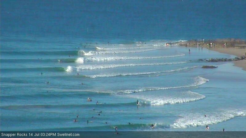
Recap: Saturday delivered some fun waves across open beaches with an easing south swell and generally light winds however Sunday’s building south swell was marred by gusty W/SW tending SW then S’ly winds in most areas. We’ve seen marginally lighter winds in most areas today and a moderate S/SE swell, but the semi exposed SE Qld points have seen the best waves (albeit small in sizes) with clean conditions and some lovely peelers on offer (check the Superbank surfcam grab from earlier this afternoon).
This week (July 15-18)
The current S/SE swell will fade slowly throughout the short term forecast period, however Tuesday should deliver great waves at exposed beaches with generally light winds on offer.
South swell magnets in Northern NSW should still be somewhere in the 3-4ft range at first light (easing to 2-3ft during the day) but it’ll be smaller north of the border with the best waves at northern ends around the 3ft mark (expect much smaller waves on the points and at protected beaches). Aim for an early surf because conditions will deteriorate in the afternoon with a light to moderate onshore airstream.
Through Wednesday and Thursday, surf size will really start to drop out and surfing opportunities will be confined to exposed swell magnets in Northern NSW - in fact by Thursday it may very well be minuscule at most beaches. However conditions will be clean with freshening offshore winds, becoming quite gusty in the south Thursday as a vigorous front crosses the region.
Friday has a strong new south swell on the cards - mainly for the Mid North Coast - that’ll be generated in the wake of Thursday’s front. In fact, we’re looking at an extended period of strong south swell, all related to an amplification of the Long Wave Trough over New Zealand longitudes from Friday onwards.
Friday will see building energy from about mid-morning onwards that should push upwards of 5-6ft+ at south facing beaches by the end of the day, south of about Coffs Harbour. Gusty SW winds will confine the best waves into sheltered southern corners where the surf will be much smaller.
However, the Far Northern NSW coast (and by association, SE Qld) probably won’t see an appreciable increase until very late in the day - of which locations north of the border will see far smaller wave heights due to the acute southerly swell direction. So, for the most part expect very small conditions in the Far North and in SE Qld for much of the day ahead of a possible late surge in size. Winds will be a little lighter here (and more W/SW in direction earlier) before tending fresh SW throughout the afternoon.
This weekend (July 19-20)
The various computer models are all in agreeance about the positioning off the Long Wave Trough across NZ longitudes over the weekend, however they differ in their predictions of where the primary fetch will be steered through the Tasman Sea, and to what strength. This will have a bearing on the eventual size and strength of the surf (as well as surface conditions).
So whilst we should be a little cautious with the numbers at this early time, the overarching weekend theme is for a very large south swell peaking somewhere in the 6-8ft range at south facing beaches in Northern NSW (smaller elsewhere). Conditions will only be suitable for protected locations though, with generally fresh S/SW winds, strong at times in the south (and possibly W/SW in a few select areas early mornings).
Although southerly swells are rarely very good for SE Qld, this one is expected to be reasonably sizeable with plenty of strength so we should see some small runners across the semi-exposed points, at this stage in the 3ft+ range. Let’s see how the models are panning out on Wednesday.
Long term (July 21 onwards)
As the Long Wave Trough slowly clears to the east early next week, the frontal systems steered along its western flank will slowly push outside of our swell window, leading to a decrease in surf size. However this may not happen until Tuesday or Wednesday (we may see one final system push into our south swell window late Sunday, providing another strong pulse for Monday).
As such, we’re looking at plenty of south swell for the first half of next week, with smaller surf settling in for the back half. Other than that there are no other sources of new swell on the radar for the long term period.


