Great South Coast, followed by the Mid Coast
South Australian Forecast by Craig Brokensha (issued Friday November 29th)
Best Days: South Coast tomorrow morning and Sunday ahead of the change, South Coast Monday and Tuesday morning, Mid Coast Wednesday onwards
Features of the Forecast (tl;dr)
- Easing SW groundswell tomorrow with variable offshore winds ahead of sea breezes
- Smaller, inconsistent SW swell Sun with W/NW winds, tending S late PM
- Inconsistent W/SW groundswell Mon with N/NE tending fresh N/NW winds down South, E/NE early on the Mid
- Moderate + sized W/SW groundswell building Tue PM, peaking Wed/Thu, easing slowly after
- NW tending SW winds Tue, E/SE tending SW Wed/Thu (E/NE down South in the AM)
Recap
Wednesday’s windswell eased back to 1-2ft yesterday inside the gulf with cleaner, lumpy conditions for the keen while the South Coast saw a chunky S’ly windswell kick up to the 4ft range through the day.
Today we’ve got our long-range SW groundswell filling in with 1.5ft sets on the Mid Coast and chunky 4ft waves down South under variable offshore winds that are now going a bit sea breezy.

New swell with west winds this morning
This weekend and next week (Nov 30 - Dec 6)
Today’s SW groundswell is due to peak this afternoon and ease back through tomorrow and winds look good for both coasts again, variable offshore down South and inside the gulf but with fading 3ft+ and 1ft surf respectively.
Sunday looks smaller but some background SW swell energy should maintain 2ft to possibly 3ft sets across Middleton under a morning, W/NW breeze. Winds might hold most of the day before reverting back to the S’th later afternoon.
On Monday, our long-range W/SW groundswell is expected to be in the water. As touched on during the week, the source was a distant storm following the low linked to today’s swell and we’re only expecting very slow but good 3ft waves across Middleton with 1-1.5ft sets inside the gulf.
Morning winds look great for both coasts, N/NE down South and E/NE inside the gulf but the afternoon will see fresher N/NW winds kick in, easing into the evening.
Easing surf with a NW tending SW change is then due Tuesday, along with an afternoon increase in new W/SW groundswell that’s due to peak Wednesday/Thursday.
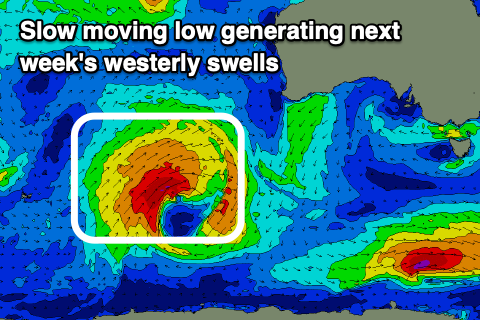
The low linked to the swell will be a slow moving one, with it firing up to the South West of Western Australia today, spawning off a strong frontal system.
Over the coming days we’re set to see fetches of W/SW gales projected through our western swell window, with the low stalling tomorrow before pushing north-east towards WA while weakening into Sunday/Monday, though followed by healthy but unfavourably aligned frontal activity.

This will produce various pulses of inconsistent westerly swell, building Tuesday afternoon peaking Wednesday/Thursday.
The Mid Coast looks to build to 2ft Tuesday afternoon but with the change, while Wednesday/Thursday look to come in at 2-3ft with morning offshore winds ahead of sea breezes.
Middleton looks to be mostly 3-4ft or so and with E/NE tending SE winds but well have to review this on Monday.
The less favourably aligned frontal activity should keep the Mid Coast topped up with fun surf into the end of the week and next weekend, but we’ll confirm this on Monday. Have a great weekend!


Comments
been looking forward to monday for about a week @craig, funsize waves (can be shoulderless unless you get that stiff offshore on the back of a swell down here, as you know), might be a little fiddly, but there's some great banks on the long beach-bays around robe, beachport, canunda, that weren't scuppered by winter, and are just continuing to getly build. thanks, craig.