Good run for the South Coast
South Australian Forecast by Craig Brokensha (issued Wednesday November 27th)
Best Days: Every morning South Coast, Mid Coast next Wednesday/Thursday
Features of the Forecast (tl;dr)
- Easing windswell tomorrow with strong S-S/SE winds
- Moderate sized SW groundswell building Fri, peaking in the PM with W/NW tending S/SE winds down South, S/SE tending SW on the Mid
- Easing swell Sat with variable winds, tending SW and freshening into the PM
- Small S/SW swell Sun with W/NW tending S winds
- Moderate sized, inconsistent W/SW groundswell Mon with N/NE tending variable winds
- Smaller Tue with variable tending S winds
- Moderate + sized W/SW groundswell Wed with SE to SW winds
Recap
The new W/SW swell filled in nicely yesterday with 1-1.5ft sets across the Mid Coast as early winds added bumps before going variable into the afternoon. The South Coast also picked up nicely to 3ft with weak sea breezes not hampering conditions too much.
Today the swell is fading but clean down South, while a strong low moving in from the west is kicking up windswell inside the gulf.

Good new swell yesterday afternoon with weak sea breezes
This week and weekend (Nov 28 - Dec 1)
Tomorrow is still due to be a lay day as we fall under the backside of the low currently moving across us, with it bringing strong S-S/SE winds.
The Mid Coast will be semi-clean but bumpy along with tiny, fading levels of windswell.
Into Friday we’re expected to see winds go variable, tending light W/NW across the South Coast and S/SE inside the gulf.
This will be along with our strong but inconsistent pulse of SW groundswell that’s due to build and peak into the afternoon.
There’s no change to the expected size with the South Coast due to reach 4-5ft off Middleton while the Mid Coast only looks to reach 1-1.5ft. Unfortunately sea breezes will spoil the peak of the swell, while Saturday looks fun as the swell eases under variable winds out of the east, before shifting SW and freshening into the afternoon.
Into Sunday a morning W/NW breeze is due, shifting S’th through the day as another trough slips through the region.
Swell wise, a strong frontal system currently tracking south-east towards the polar shelf should generate a small S/SW groundswell to 2ft+ across Middleton, with tiny waves inside the gulf.
Moving into next week and winds are due to swing back to the N/NE along with a new, long-range W/SW groundswell for Monday.

The source is a very distant storm that developed south-east of South Africa and is now moving through the Indian Ocean, with it due to provide inconsistent 3ft waves off Middleton with 1-1.5ft sets inside the gulf.
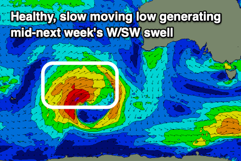
This swell will ease into Tuesday but of greater significance is a moderate + sized W/SW groundswell due on Wednesday.
This is set to be generated by a great low forming to the south-west of Western Australia, producing a slow moving fetch of gales while moving through our western swell window. Local winds look south-east at this stage, but more on this Friday.

