More west swell later week with mixed winds
South Australian Forecast by Craig Brokensha (issued Monday October 21st)
Best Days: Both coasts today, both coasts Friday morning, South Coast Saturday
Features of the Forecast (tl;dr)
- Easing W/SW swell tomorrow with S/SW winds on the South Coast, S/SE in the AM across the Mid
- Freshening SW winds Wed, possibly variable early
- Moderate sized W/SW swell Thu with gusty SW winds
- Reinforcing, inconsistent W/SW swell Fri with E winds on the Mid Coast, variable down South ahead of sea breezes
- Easing swell Sat with N/NE tending NW winds
- Tiny Sun with strong SW winds
Recap
It was a poor weekend of waves across the South Coast with onshore winds Saturday, cleaner Sunday but tiny. The Mid Coast was tiny Saturday while a new W/SW swell filled in yesterday, pulsing to 1-1.5ft for the keen.
This swell has been reinforced by a stronger pulse today with clean but slow 1-2ft sets, clean also down South but a slow 2ft.

Glassy, full lines this morning
This week and weekend (Oct 22 - 27)
Today’s W/SW swell is due to fade through tomorrow and unfortunately for the South Coast, a trough looks to bring a S/SW change just before dawn, with S/SE winds inside the gulf but fading 1-1.5ft sets.
Wednesday looks mostly small to tiny again and another approaching front looks to bring freshening SW winds that may be variable through the early morning. Regardless, with no real swell it looks tiny.

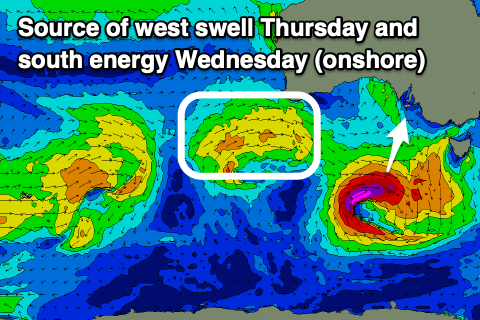
This front should generate some fun new W/SW swell for Thursday, with it currently projecting towards the south-west corner of Western Australia.
Into this evening and tomorrow morning, a good fetch of strong W’ly winds are forecast to be projected through our western swell window, with 2ft+ of swell due across the Mid Coast Thursday, with some longer-range, less consistent energy from the earlier stages of the front due to maintain 2ft waves on Friday.
The South Coast looks to come in only around 2ft across Middleton owing to the westerly swell directions and winds on Thursday unfortunately look to persist from the SW across all locations, better Friday and light E’ly across the Mid Coast with variable breezes down South ahead of sea breezes.

The South Coast will become cleaner on the weekend but with small, fading levels of swell to 1-2ft or so (Middleton) Saturday under a N/NE offshore. Sunday then looks poor as a strong SW change moves through around dawn.
This will be thanks to a stream of healthy frontal activity moving in under the country from late week through the weekend, generating fun levels of W/SW swell with south to south-east winds. More on this in Wednesday’s update.

