Large westerly swells for the weekend

South Australian Forecast by Craig Brokensha (issued Friday August 30th)
Best Days: Protected spots Saturday/Sunday and Monday morning South Coast, both coasts Tuesday, South Coast Wednesday, South Coast Thursday morning
Features of the Forecast (tl;dr)
- Large, powerful W/SW groundswell building tomorrow PM, peaking Sun, easing Mon
- Strong W/NW winds Sat/Sun, tending NW at times
- Large mid-period SW swell Mon PM, easing Tue
- Strong W/SW winds Mon (W/NW morning Victor), easing a touch later
- Light E/NE-NE tending N/NE then variable winds Tue on the Mid, N/NE tending variable down South
- Strengthening N/NE tending N/NW winds Wed
- Moderate sized, inconsistent SW groundswell Thu with variable tending onshore winds
Recap
There was a window of OK conditions across the Mid Coast yesterday morning with strong 3ft sets under north winds, deteriorating into the afternoon.
The South Coast saw large surf with improving conditions as the day went on along with a slight drop in swell, smaller today and to 3-4ft but with stronger cross-shore winds. These winds will kick up a stormy increase in swell for the Mid Coast later.
This weekend and next week (Aug 31 - Sep 6)
One swell down, with plenty more to come for the weekend.
A large southern ocean gyre has developed south of the country, with multiple embedded fronts spinning around its core, generating various pulses of large swell from tomorrow through Tuesday.
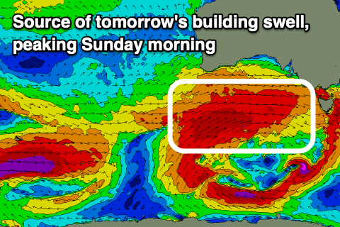
Our secondary larger swell producer for the weekend is currently moving in from the west, with a broad fetch of gale to severe-gale W/SW winds projecting towards us, generating a large pulse of building W/SW for tomorrow (peaking Sunday morning), that will then be boosted further into Sunday by a secondary front generating severe-gale W’ly winds on top of the active sea state during tomorrow.
Coming back to tomorrow and we should see the swell building steadily through the day, likely from 4-6ft in the morning on the South Coast across Middleton, towards 6-8ft later in the day.
This secondary front will generate large, long period surf for Sunday, with the South Coast due to come in at 8ft+.

The Mid Coast will ebb and pulse between a choppy 3-4ft though winds will favour the South Coast, generally strong from the W/NW but tending more NW at times, mostly into the afternoons.
Into Monday, we’ve got a third and final significant frontal system due, with it generating a broad fetch of W/SW in our south-western swell window. This will produce a large reinforcing mid-period SW swell for Monday afternoon and Tuesday morning.
Middleton should hold in the 6-8ft range with 3ft+ sets inside the gulf Monday, easing from the 6ft+ and 2-3ft range respectively Tuesday.
Winds will shift strong W/SW and hold most of the day now unfortunately with no real window of cleaner conditions for the Mid Coast. The South Coast should see a morning W/NW breeze though.
Tuesday looks better as winds ease right off, tending E/NE-NE during the morning inside the gulf then more N/NE ahead of variable sea breezes. The South Coast looks great all day with N/NE tending variable winds.
Easing surf is then due Wednesday along with strengthening N/NE tending N/NW winds.
Into the end of the week, some trailing frontal activity out in the Indian Ocean looks to generate some good, reinforcing W/SW groundswell for Thursday under variable winds. More on this Monday. Have a great weekend!
Comments
Cape du couedic just recorded a 45m set lol - gotta be glitch surely
Tassie buoy is not broken but cdc is fried!!