Windy, large swells inbound

South Australian Forecast by Craig Brokensha (issued Friday August 23rd)
Best Days: South Coast today, South Coast tomorrow, keen surfers Monday morning Mid Coast, Tuesday South Coast, South Coast from Thursday onwards
Features of the Forecast (tl;dr)
- Easing swell through the weekend with mod-fresh N/NW winds tomorrow, easing later
- Smaller Sun with strong N/NW tending W/NW winds
- Building W/NW windswell into the PM Sun across the Mid Coast
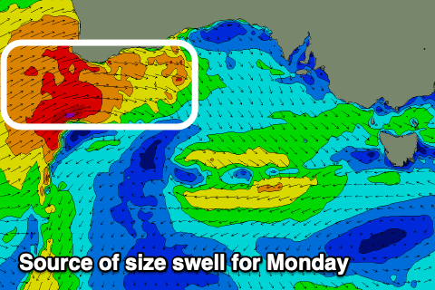
- Large W'ly swell Mon with mod-fresh W/NW winds, strengthening
- Easing swell Tue, replaced by a long-range W/SW groundswell with strong N/NW winds
- Building stormy W swell Wed with strong W winds
- Larger W/SW-SW groundswells next week/weekend with strong W/NW-W winds
Recap
A small, slow W/SW groundswell provided inconsistent 1-2ft waves down South across Middleton with clean conditions, tiny and wind affected inside the gulf but improving later as winds eased along with slow 1-2ft sets.
Today the swell is hanging in at a slow 1-2ft in the gulf but conditions are deteriorating with strengthening N/NE winds that will shift more N/NW on dark. The South Coast is the pick with clean conditions and surf to 3-4ft off Middleton, but with an easing trend due through the day.
This weekend and next week (Aug 24 - 30)
We’ve got easing surf all weekend following this morning’s pulse and peak of W/SW swell.
This is thanks to the swell generating frontal system moving in under the Bight clearing south-east of us yesterday.
Easing 2-3ft sets are due across Middleton tomorrow with tiny waves inside the gulf as winds favour the South Coast, moderate to fresh from the N/NW, easing later.
Sunday will become smaller with strengthening N/NW tending W/NW winds. This will kick up some building windswell inside the gulf, likely reaching 2-3ft by dark.
Now, this approaching frontal system should also generate a large spike of W’ly swell on Monday. A tight, high riding fetch to gale-force W’ly winds are due to generate 3ft+ of swell inside the gulf with a brief easing of moderate to fresh W/NW winds, strengthening into the afternoon as the next system approaches.
The westerly nature of the swell won’t favour the South Coast with Middleton only likely to see slow 2ft sets.
This swell should ease into Tuesday, though an inconsistent, long-range W/SW groundswell will take its place, generated by a singifciant frontal progression through the Indian Ocean. Middleton looks to be a slow 3ft, 2ft+ inside the gulf but with strengthening N/NW winds, favouring the South Coast.
We’ve then got a significant cold outbreak due under the country into the middle to end of the week.
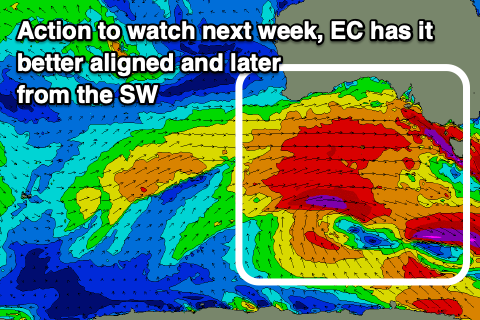
The source will actually be the remnants of a strong low that’s spawned off Madagascar, with this due to traverse the Indian Ocean, combining with a strong frontal system projecting from the south-west of WA.
The models diverge regarding the makeup of this outbreak as it moves in towards us, with GFS showing an earlier evolution of swell through Wednesday/Thursday while EC has it more delayed and into Thursday/Friday.
EC has been consistently nailing these systems in the Indian Ocean so I’m tempted to go with a large increase in W/SW and SW swells for later Wednesday but more so Thursday/Friday, continuing through the weekend and into September.
Winds at this stage look to be out of the western quadrant, signalling the first proper frontal progression in a long time. More on this Monday, have a great weekend!
Comments
37.9 degrees at Oodnadatta today (record temp for August), 39 degrees forecast for tomorrow.
Winter!
wow that's early Ben !
on the east coast (Hunter valley) in early October we would get a hot westerly wind come out of nowhere 38 degrees sometimes higher . I remember I'd usually be at school and feel it just come through in the mid day coming in hot from the mild of the desert...
summers coming I would think.