Persistent run of winds out of the north-eastern quadrant with some fun swell

South Australian Surf Forecast by Craig Brokensha (issued Wednesday July 3rd)
Best Days: Mid Coast Thursday, Friday, Saturday, South Coast each morning over the coming period
Features of the Forecast (tl;dr)
- Inconsistent W/SW groundswell for Thu, holding Fri AM ahead of a secondary pulse of more SW swell energy late and Sat AM
- E/SE tending S/SE-SE winds in the gulf Thu/Fri, E/SE-E all day Sat/Sun
- Moderate E/NE-NE tending gusty S/SE-SE winds Thu/Fri, E/NE-NE tending E winds Sat/Sun
- Small reinforcing S/SW groundswell Mon AM, easing with fresh N/NE-NE winds
- Tiny Tue with N/NW tending W/NW winds
Recap
The South Coast has been a little lumpy and peaky but fun with light offshore tending weak onshore breezes yesterday along with 3ft of swell, back to the 2ft range this morning.
The Mid Coast saw 1ft sets yesterday, back to 0.5ft today.
This week and weekend (Jul 4 - 6)
The coming period will be dominated by the monster high sitting south of us, with it possibly breaking the record for the highest pressure registered in Australia over the coming days. I’ve discussed this in more detail in this article: Riding A July High
The high will have a huge effect on the local surf, with it blocking any major storms from firing up in our main swell window, but on the other hand, provide a great run for exposed coasts exposed beaches as winds hold from the north-eastern quadrant.
So looking at the coming days and some strong, inconsistent W/SW groundswell is due to arrive through tomorrow with it pumping currently in Margaret River and most of Western Australia.
We should see sets to an inconsistent but good 2ft on the favourable parts of the tide through tomorrow in the gulf, holding Friday and then easing into the weekend.
The South Coast will be less consistent but should build to 3-4ft through tomorrow, hold Friday and then increase further in size.
Local winds will be great for the Mid Coast and E/SE tending variable over the coming days, while the South Coast will come in a little peaky at times with an E/NE-NE tending fresh S/SE-SE wind tomorrow and Friday.
Now, into the late afternoon Friday but more so Saturday morning, our stronger pulse of SW groundswell is due, generated by the first of a series of south-east but strong tracking fronts down towards the polar shelf.
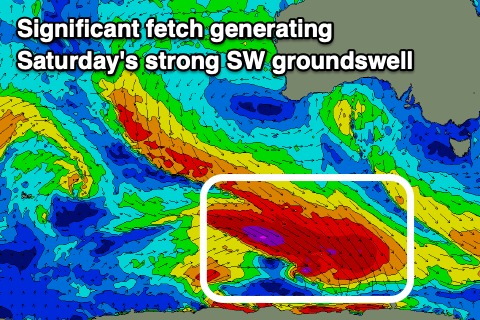
This first system looks the most significant with a great fetch of severe-gale W/NW winds being generated, producing a moderate + sized SW groundswell for Saturday to 4-5ft across Middleton, easing into the afternoon and further Sunday from 3ft on the sets. The Mid Coast won’t see any real size from this swell with inconsistent, easing 1-2ft sets Saturday, tiny Sunday.
E/SE winds will persist on the Mid Coast Saturday, tending E/NE-NE during the morning down South, with Sunday playing out similarly.
Into Monday, a small pulse of fun S/SW swell is due, generated by weaker but trailing frontal activity projecting towards the polar shelf, coming in 2ft+ across Middleton under fresher N/NE-NE winds. The Mid Coast will be tiny and wind affected.
The swell will then fade into the afternoon and further Tuesday as winds shift more NW-W/NW.
This will be as the high starts moving east and frontal activity begins edging in from the west, bringing some new energy later week and beyond. More on this Friday.
Comments
Will there be much north in the winds on Sunday? Seeing a lot of east...
It'll be E/NE-NE, mostly towards NE during the morning.